IMAGES TAKEN NEAR TO
Kirknewton, WOOLER, NE71 6XW
Introduction
This page details the photographs taken nearby to NE71 6XW by members of the Geograph project.
The Geograph project started in 2005 with the aim of publishing, organising and preserving representative images for every square kilometre of Great Britain, Ireland and the Isle of Man.

There are currently over 7.5m images from over14,400 individuals and you can help contribute to the project by visiting https://www.geograph.org.uk
Image Map
Images are licensed for reuse under creativecommons.org/licenses/by-sa/2.0
Notes
- Clicking on the map will re-center to the selected point.
- The higher the marker number, the further away the image location is from the centre of the postcode.
Image Listing (18 Images Found)
Images are licensed for reuse under creativecommons.org/licenses/by-sa/2.0
Image
Details
Distance
1
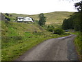
The elevated farmhouse at Elsdonburn
Image: © Phil Catterall
Taken: 25 Sep 2007
0.00 miles
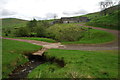
2
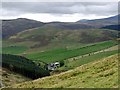
Elsdonburn from Ring Chesters
The hill directly behind the farm is Great Hetha. The enclosing bank of the hill fort can be seen around its summit. Hare Law is behind to the left. The cone of Hedgehope Hill can be seen above the shoulder of Cheviot on the right.
Image: © Andrew Curtis
Taken: 28 Sep 2012
0.00 miles
3

Elsdonburn & Ring Chesters from Great Hetha
Image: © Andrew Curtis
Taken: 28 Sep 2012
0.00 miles
4
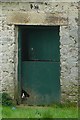
Can I come and play?
We wondered where the whining was coming from, Then we saw this sorrowful head poking through a gap in the barn door.
Image: © Graham Horn
Taken: 31 Aug 2009
0.01 miles
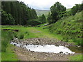
6
Ford at Elsdonburn
This ford is found on the Elsdon Burn at Elsdonburn.
Image: © John Walton
Taken: 8 May 2014
0.02 miles
7
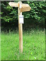
Signpost Near Elsdonburn
This signpost has just recently been erected, replacing an older one which stood in the same location. A notice has been attached to the post by the Northumberland National Park Authority giving "important information" to walkers regarding Coronavirus (Covid-19). For a selection of detailed free to download walking routes in the area visit www.cheviotwalks.co.uk
Image: © Geoff Holland
Taken: 23 Jun 2020
0.02 miles
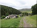
8
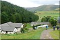
Elsdonburn
The farm takes the same name as the burn in whose valley it is situated. Here the St Cuthbert's Way path passes between the farm buildings.
Image: © Graham Horn
Taken: 31 Aug 2009
0.03 miles
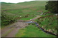
9
Ford Near Elsdonburn
The rough track crosses the Elsdon Burn via this shallow ford, and once through the metal gate beyond, joins the surfaced road serving the lonely farm of Elsdonburn. For a selection of detailed free to download walking routes in the area visit www.cheviotwalks.co.uk
Image: © Geoff Holland
Taken: 23 Jun 2020
0.04 miles
10
Ford at Elsdonburn
This is a second ford on the track beyond Elsdonburn.
Image: © John Walton
Taken: 8 May 2014
0.04 miles