IMAGES TAKEN NEAR TO
South Road, WOOLER, NE71 6NW
Introduction
This page details the photographs taken nearby to South Road, NE71 6NW by members of the Geograph project.
The Geograph project started in 2005 with the aim of publishing, organising and preserving representative images for every square kilometre of Great Britain, Ireland and the Isle of Man.

There are currently over 7.5m images from over14,400 individuals and you can help contribute to the project by visiting https://www.geograph.org.uk
Image Map
Images are licensed for reuse under creativecommons.org/licenses/by-sa/2.0
Notes
- Clicking on the map will re-center to the selected point.
- The higher the marker number, the further away the image location is from the centre of the postcode.
Image Listing (212 Images Found)
Images are licensed for reuse under creativecommons.org/licenses/by-sa/2.0
Image
Details
Distance
1
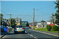
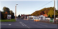
Wooler : South Road A697
Heading north through Northumberland on the A697.
Image: © Lewis Clarke
Taken: 21 Sep 2020
0.01 miles
2
Former flour mill, Wooler
Image: © Barbara Carr
Taken: 7 May 2013
0.03 miles
3
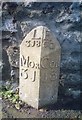
Old Milepost by the A697, South Road, Wooler
Cast iron post by the A697, in parish of WOOLER (BERWICK UPON TWEED District), South Road by Millvale, back of footpath, against stone wall, on West side of road. MOR/COR iron post, erected by the Percy's Cross to Millfield turnpike trust in the 19th century.
Inscription reads:-
: MOR / 31 : : L / 318 : : E / 60 : : COR / 13 :
Grade II listed.
List Entry Number: 1042297 https://historicengland.org.uk/listing/the-list/list-entry/1042297
Milestone Society National ID: NB_MPCH31.
Image: © IA Davison
Taken: 15 Oct 2004
0.03 miles
4
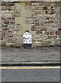
Old Milepost by the A697, South Road, Wooler
Cast iron post by the A697, in parish of WOOLER (BERWICK UPON TWEED District), South Road by Millvale, back of footpath, against stone wall, on West side of road. MOR/COR iron post, erected by the Percy's Cross to Millfield turnpike trust in the 19th century.
Inscription reads:-
: MOR / 31 : : L / 318 : : E / 60 : : COR / 13 :
Grade II listed.
List Entry Number: 1042297 https://historicengland.org.uk/listing/the-list/list-entry/1042297
Milestone Society National ID: NB_MPCH31
Image: © Graeme Stark
Taken: 12 Sep 2023
0.03 miles
5
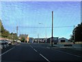
Junction of Weetwood Road and South Road (A697), Wooler
Image: © habiloid
Taken: 18 Aug 2021
0.03 miles
6
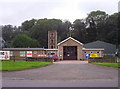
Wooler Fire Station
Wooler fire station on the A697.
Image: © Weston Beggard
Taken: 14 Oct 2006
0.03 miles
7
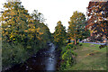
Wooler Water
View from the Weetwood Road bridge.
Image: © habiloid
Taken: 18 Aug 2021
0.03 miles
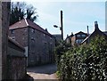
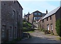
9

Steps to the flour mill
A lane from Church Street follows these steps down to the old flour mill (on the right), see Image and Image
From the 'Town and Country Trail' leaflet available from Image:
"This three storey flour mill which appears on the 1769 County Map - recently renovated and refurbished to form a private dwelling - was the fourth mill to be fed by the mill race which ran from Earle Mill (one mile south). Little remains of the carding mill or the dye mill, though the mill race can still be seen at Earle Mill (which has also been renovated)."
Image: © Barbara Carr
Taken: 7 May 2013
0.04 miles
10
Former flour mill and steps to Church Street
See Image
Image: © Barbara Carr
Taken: 7 May 2013
0.04 miles