IMAGES TAKEN NEAR TO
Fiveacres, WOOLER, NE71 6LZ
Introduction
This page details the photographs taken nearby to Fiveacres, NE71 6LZ by members of the Geograph project.
The Geograph project started in 2005 with the aim of publishing, organising and preserving representative images for every square kilometre of Great Britain, Ireland and the Isle of Man.

There are currently over 7.5m images from over14,400 individuals and you can help contribute to the project by visiting https://www.geograph.org.uk
Image Map
Images are licensed for reuse under creativecommons.org/licenses/by-sa/2.0
Notes
- Clicking on the map will re-center to the selected point.
- The higher the marker number, the further away the image location is from the centre of the postcode.
Image Listing (146 Images Found)
Images are licensed for reuse under creativecommons.org/licenses/by-sa/2.0
Image
Details
Distance
1
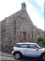
A church hall in Wooler
Once 'The Methodist Chapel', now Wooler United Reformed Church's 'The Glendale Hall'. Both names maintained on the facade.
Image: © Stanley Howe
Taken: 21 Aug 2013
0.02 miles
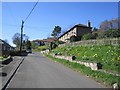
2
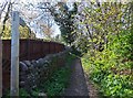
Bridleway near youth hostel, Wooler
This bridleway runs between Cheviot Street and Broomey Road, affording wonderful views of the local countryside.
Image: © Barbara Carr
Taken: 7 May 2013
0.03 miles
3
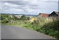
Bend in road near Horsdon Farm
With a view over the valley of the River Till.
Image: © Stanley Howe
Taken: 21 Aug 2013
0.03 miles
4
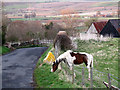
Greener grass
This horse at Horsden Farm appears to be demonstrating the proverb that “the grass is always greener on the other side of the fence”.
Image: © Stephen Craven
Taken: 25 Apr 2013
0.04 miles
5
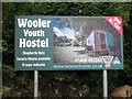
Sign at entrance to Wooler Youth Hostel
The first Youth Hostel in Wooler was opened in 1932 in the town`s old railway station with the waiting rooms being converted into accommodation for men on one side of the tracks, and for women on the other side. That hostel closed in 1939 at the outset of World War II and was never again used as a hostel. The town remained without a hostel until October 1953 when the current building, which had been erected in the early 1940`s as a Women`s Land Army hostel, was purchased by the YHA. It opened for business in August 1954 and is currently leased by the now owners (the Glendale Trust) to local couple Karl and Cindy Wait. For a selection of detailed free to download walking routes in the area visit www.cheviotwalks.co.uk
Image: © Geoff Holland
Taken: 4 Jun 2019
0.04 miles
6
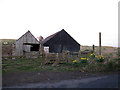
Footpath to Wooler Haugh
The path leaves the road next to this pair of wooden sheds at Horsden Farm.
Image: © Stephen Craven
Taken: 25 Apr 2013
0.04 miles
8
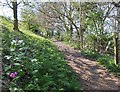
Bridleway on the southern edge of Wooler
A wonderfully-warm spring day, with the trees coming into leaf and honesty in flower.
Image: © Barbara Carr
Taken: 7 May 2013
0.06 miles
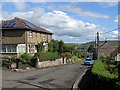
9
Cheviot Road, Wooler
Steep residential street on the south side of the town.
Image: © Richard Webb
Taken: 30 Apr 2013
0.07 miles
10
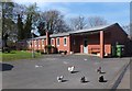
Wooler Youth Hostel
Wooler Youth Hostel - and feather-legged hens!
From 'Town and Country Trail', available from Image:
"This single storey 'U' shaped building was built in 1940 as the Land Army Hostel. The 30-40 'Land Girls' living here worked the land, drove the tractors, pulled turnips and still had time for the local dances! Several still live in the town - having married local men. Later used to house Latvian refugees, it was converted to Youth Hostel accommodation in 1954."
Image: © Barbara Carr
Taken: 7 May 2013
0.07 miles