IMAGES TAKEN NEAR TO
BELFORD, NE70 7QQ
Introduction
This page details the photographs taken nearby to NE70 7QQ by members of the Geograph project.
The Geograph project started in 2005 with the aim of publishing, organising and preserving representative images for every square kilometre of Great Britain, Ireland and the Isle of Man.

There are currently over 7.5m images from over14,400 individuals and you can help contribute to the project by visiting https://www.geograph.org.uk
Image Map (Loading...)


Getting Data...Please wait
Leaflet Map data © OpenStreetMap
Images are licensed for reuse under creativecommons.org/licenses/by-sa/2.0
Notes
- Clicking on the map will re-center to the selected point.
- The higher the marker number, the further away the image location is from the centre of the postcode.
Image Listing (15 Images Found)
Images are licensed for reuse under creativecommons.org/licenses/by-sa/2.0
Image
Details
Distance
2
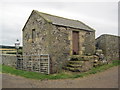
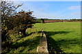
West Hall Farm
West Hall farm as seen from a footpath running through the adjacent grass field.
Image: © Graham Robson
Taken: 1 Mar 2012
0.03 miles
5
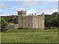
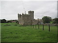
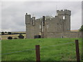
Westhall
Westhall is a privately owned castellated fortified house that has been surrounded by a moat. It is mentioned in a 15th century document as the Castrum de Belford.
Image: © Mark Percy
Taken: 10 Jul 2010
0.07 miles
6
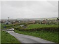
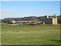
Road towards Westhall
Looking down the country road towards the buildings at Westhall farm. The buildings of Belford can be seen in the distance behind the buildings at Westhall.
Image: © Graham Robson
Taken: 17 May 2012
0.09 miles
7
Beside Belford Burn
Following the Northumberland Coast Path beside Belford Burn, near Westhall.
Image: © Chris Heaton
Taken: 8 Oct 2014
0.13 miles
8
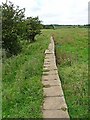
St Oswald's Way near Westhall Farm
This path runs along a line of capping stones which form part of an old dam which held back a pond near Westhall Farm. The slightly raised larger stone straddles an old sluice gate. The path carries St Oswald's Way (Lindisfarne to Heavenfield near Hexham) and the Northumberland Coast Path (which at this point is well inland).
Image: © Oliver Dixon
Taken: 15 Aug 2010
0.14 miles
9
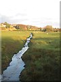
Belford Burn
Looking downstream along Belford Burn as it flows through a grass field at West Hall on the outskirts of Belford.
Image: © Graham Robson
Taken: 4 Feb 2014
0.16 miles
10
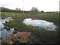
Recently created pond beside Belford Burn
The pond on the right has been recently created as part of the Belford Flood Alleviation Scheme.
The scheme is the result of a research project by Newcastle University and the Environment Agency to develop a low cost, low impact plan to reduce the risk of flooding to a small number of properties in Belford. The scheme features a large number of small scale alterations to the landscape including creating natural barriers to the flow of water (both overland and along the channel) and creating ponds (such as the one shown here) to intercept and store water in times of high flow and then allow a gradual release of water when water levels in the stream drop.
Image: © Graham Robson
Taken: 4 Feb 2014
0.16 miles