IMAGES TAKEN NEAR TO
Hillside Road, BELFORD, NE70 7NB
Introduction
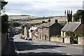
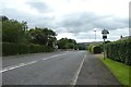
This page details the photographs taken nearby to Hillside Road, NE70 7NB by members of the Geograph project.
The Geograph project started in 2005 with the aim of publishing, organising and preserving representative images for every square kilometre of Great Britain, Ireland and the Isle of Man.

There are currently over 7.5m images from over14,400 individuals and you can help contribute to the project by visiting https://www.geograph.org.uk
Image Map (Loading...)


Getting Data...Please wait
Leaflet Map data © OpenStreetMap
Images are licensed for reuse under creativecommons.org/licenses/by-sa/2.0
Notes
- Clicking on the map will re-center to the selected point.
- The higher the marker number, the further away the image location is from the centre of the postcode.
Image Listing (164 Images Found)
Images are licensed for reuse under creativecommons.org/licenses/by-sa/2.0
Image
Details
Distance
1
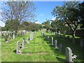
St Mary's graveyard - nearly full
The graveyard in the grounds of St Mary's parish church is running out of available plots, the only unoccupied area being in the far right corner of the graveyard.
Image: © Graham Robson
Taken: 14 Jun 2012
0.06 miles
2
Approaching Belford from the north
The flag on the Parish Church of St. Mary is extended by a stiff breeze.
Image: © Russel Wills
Taken: 8 Aug 2016
0.08 miles
3
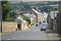
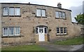
Entering Belford
Descending the hill from the Middleton direction.
Image: © DS Pugh
Taken: 12 Aug 2013
0.08 miles
4
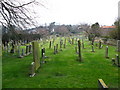
The graveyard of St Mary's Church, Belford
St Mary's church was rebuilt in 1615 with extensive renovations in 1700, although it still contains parts of a much older, probably Norman church. The church as it is today is from 1828 with a pinnacled tower, although it was damaged by lightning in 2000 and was subsequently restored.
Image: © Lisa Jarvis
Taken: 29 Mar 2007
0.08 miles
5
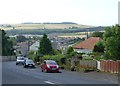
North Bank, Belford
The old A1 climbs north from the village centre to cross the ridge formed by the igneous intrusive rocks running east-west from Bamburgh.
Image: © Richard Kay
Taken: 12 Aug 2009
0.09 miles
6
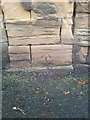
OS Cut Mark - North Bank, Belford
B01481 - OS Cut Mark: Belford, North Bank
Image: © thejackrustles
Taken: 15 Sep 2014
0.09 miles

8
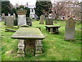
The graveyard, St Mary's Church
St Mary's church was rebuilt in 1615 with extensive renovations in 1700, although it still contains parts of a much older, probably Norman church. The church as it is today is from 1828 with a pinnacled tower, although it was damaged by lightning in 2000 and was subsequently restored.
Image: © Lisa Jarvis
Taken: 29 Mar 2007
0.10 miles
10
Road descending to Belford
Looking down the hill towards Belford.
Image: © DS Pugh
Taken: 7 Aug 2019
0.10 miles