IMAGES TAKEN NEAR TO
Clark Place, BELFORD, NE70 7LT
Introduction
This page details the photographs taken nearby to Clark Place, NE70 7LT by members of the Geograph project.
The Geograph project started in 2005 with the aim of publishing, organising and preserving representative images for every square kilometre of Great Britain, Ireland and the Isle of Man.

There are currently over 7.5m images from over14,400 individuals and you can help contribute to the project by visiting https://www.geograph.org.uk
Image Map (Loading...)


Getting Data...Please wait
Leaflet Map data © OpenStreetMap
Images are licensed for reuse under creativecommons.org/licenses/by-sa/2.0
Notes
- Clicking on the map will re-center to the selected point.
- The higher the marker number, the further away the image location is from the centre of the postcode.
Image Listing (168 Images Found)
Images are licensed for reuse under creativecommons.org/licenses/by-sa/2.0
Image
Details
Distance
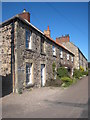
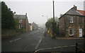
2
Clark Place, Belford
A dead end road just north of the village centre.
Image: © John Allan
Taken: 17 Aug 2017
0.01 miles
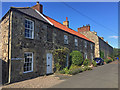
3
Clark Place
Grade II listed buildings. http://www.britishlistedbuildings.co.uk/en-408805-1-and-2-belford
Image: © N Chadwick
Taken: 1 Jun 2011
0.01 miles
4
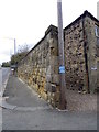
Road side wall, Belford
The wall is situated beside Church Lane. There is an Ordnance Survey flush bracket bear the telephone post.
Image: © Maigheach-gheal
Taken: 29 Oct 2011
0.02 miles
5

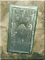
Flush Bracket 2005, Belford
The Ordnance Survey flush bracket is located on a road side wall on Church Lane. For a wider view of the wall Image and for further information on the bracket and others in the area http://www.bench-marks.org.uk/bm63
Image: © Maigheach-gheal
Taken: 29 Oct 2011
0.02 miles
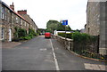
6
Belford once the A1
Looking north by the church.
Image: © roger geach
Taken: 26 Sep 2012
0.02 miles
7
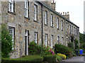
Clark Place, Belford
Belford has many modest but good stone houses, this terrace is picked out by Pevsner as "the best". It dates from c1820. Grade II listed.
Image: © Stephen Richards
Taken: Unknown
0.02 miles
8
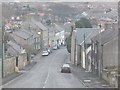
Down North Bank into Church Street
Approaching the centre of Belford from the north.
Image: © Barbara Carr
Taken: 21 Mar 2013
0.02 miles
9
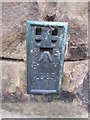
Ordnance Survey Flush Bracket (2005)
This OS Flush Bracket can be found on the wall opposite St Mary's Church. It marks a point 60.3835m above mean sea level.
Image: © Adrian Dust
Taken: 5 Oct 2015
0.02 miles
10
OS Flush Bracket 2005 - Belford, Church Street
Flush Bracket on Church Street
Image: © thejackrustles
Taken: 18 Sep 2014
0.02 miles