IMAGES TAKEN NEAR TO
Warenford, BELFORD, NE70 7HZ
Introduction
This page details the photographs taken nearby to NE70 7HZ by members of the Geograph project.
The Geograph project started in 2005 with the aim of publishing, organising and preserving representative images for every square kilometre of Great Britain, Ireland and the Isle of Man.

There are currently over 7.5m images from over14,400 individuals and you can help contribute to the project by visiting https://www.geograph.org.uk
Image Map (Loading...)


Getting Data...Please wait
Leaflet Map data © OpenStreetMap
Images are licensed for reuse under creativecommons.org/licenses/by-sa/2.0
Notes
- Clicking on the map will re-center to the selected point.
- The higher the marker number, the further away the image location is from the centre of the postcode.
Image Listing (17 Images Found)
Images are licensed for reuse under creativecommons.org/licenses/by-sa/2.0
Image
Details
Distance
1
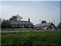
Cottage on the side of the A1, south of Warenford
Looking across the A1 to a roadside cottage south of Warenford from the footpath connecting the village with the cricket ground to the south. At this point the path runs in a gully below the level of the road, hence the low camera angle.
Image: © Graham Robson
Taken: 28 May 2013
0.01 miles
2
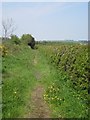
Footpath south of Warenford
This footpath runs between the A1 on the left, and arable land on the right. It connects the village of Warenford, which is ahead, with Warenford Cricket Club, which is around a kilometre to the south.
Image: © Graham Robson
Taken: 28 May 2013
0.05 miles
3
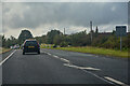
Adderstone with Lucker : A1
Heading south on the A1.
Image: © Lewis Clarke
Taken: 25 Sep 2020
0.06 miles
4

A1 towards Berwick
Heading north west - track towards Lucker on the right.
Image: © JThomas
Taken: 2 May 2014
0.08 miles

6

Ratchwood junction
A minor road/track (one of those 'public access' ways which does not fit normal footpath/bridleway criteria) leads to Ratchwood, which is marked on the map as a ruin - another one to remember for exploration on a sunnier day! There are lots of mole-hills in the verge: I cannot remember any year when there's been so much mole-activity - given the water-logged condition of so much ground, perhaps this is a time where the activities of 'the little gentleman in the velvet coat' might actually be welcomed as an aid to drainage.
Image: © Barbara Carr
Taken: 21 Mar 2013
0.09 miles

8
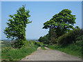
Track to Ratchwood
Looking along the track to Ratchwood from its junction with the A1.
Image: © Graham Robson
Taken: 28 May 2013
0.10 miles
9
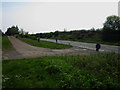
Minor road junction south of Warenford
This minor road junction on the A1 south of Warenford provides access to the farm track to Ratchwood, out of shot on the left, and access to the single dwelling at Warenford Cottage. I suspect in the past the A1 used the alignment on the left before being realigned to the route on the right.
Image: © Graham Robson
Taken: 28 May 2013
0.10 miles
10

Adderstone with Lucker : Track
A track off the A1.
Image: © Lewis Clarke
Taken: 25 Sep 2020
0.10 miles