IMAGES TAKEN NEAR TO
BAMBURGH, NE69 7AU
Introduction
This page details the photographs taken nearby to NE69 7AU by members of the Geograph project.
The Geograph project started in 2005 with the aim of publishing, organising and preserving representative images for every square kilometre of Great Britain, Ireland and the Isle of Man.

There are currently over 7.5m images from over14,400 individuals and you can help contribute to the project by visiting https://www.geograph.org.uk
Image Map
Images are licensed for reuse under creativecommons.org/licenses/by-sa/2.0
Notes
- Clicking on the map will re-center to the selected point.
- The higher the marker number, the further away the image location is from the centre of the postcode.
Image Listing (59 Images Found)
Images are licensed for reuse under creativecommons.org/licenses/by-sa/2.0
Image
Details
Distance
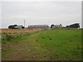
1
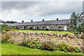
Greenhill Cottages
Row of cottages at Greenhill Farm.
Image: © Ian Capper
Taken: 22 Sep 2020
0.00 miles
2
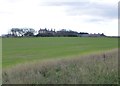
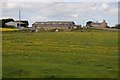
Greenhill Farm
With fine views to Bamburgh Castle, the sea and Seahouses.
Image: © Russel Wills
Taken: 4 Nov 2013
0.04 miles
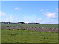
3
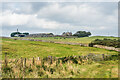
Greenhill Farm
Looking across pastureland to Greenhill Farm.
Image: © Ian Capper
Taken: 22 Sep 2020
0.04 miles
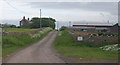
5
Greenhill Farm
Looking along a farm track to the buildings at Greenhill Farm.
Image: © Graham Robson
Taken: 14 Aug 2012
0.07 miles
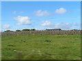
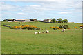
9
Greenhill
Greenhill viewed from St Oswald's Way.
Image: © Philip Halling
Taken: 3 Jun 2015
0.11 miles
10
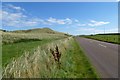
Road to Seahouses
Links Road leading from Bamburgh to Seahouses.
Image: © DS Pugh
Taken: 31 Aug 2014
0.12 miles