IMAGES TAKEN NEAR TO
BAMBURGH, NE69 7AT
Introduction
This page details the photographs taken nearby to NE69 7AT by members of the Geograph project.
The Geograph project started in 2005 with the aim of publishing, organising and preserving representative images for every square kilometre of Great Britain, Ireland and the Isle of Man.

There are currently over 7.5m images from over14,400 individuals and you can help contribute to the project by visiting https://www.geograph.org.uk
Image Map (Loading...)


Getting Data...Please wait
Leaflet Map data © OpenStreetMap
Images are licensed for reuse under creativecommons.org/licenses/by-sa/2.0
Notes
- Clicking on the map will re-center to the selected point.
- The higher the marker number, the further away the image location is from the centre of the postcode.
Image Listing (21 Images Found)
Images are licensed for reuse under creativecommons.org/licenses/by-sa/2.0
Image
Details
Distance
1
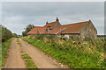
Saddlershall
House alongside the lane from Fowberry to Shoreston.
Image: © Ian Capper
Taken: 22 Sep 2020
0.00 miles
2
Saddlershall, south of Bamburgh
Red roofed house on a lane, the Northumberland Coast Path, in farmland.
Image: © Peter Barr
Taken: 22 Jun 2011
0.02 miles
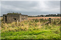
3
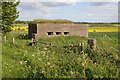
Pillbox near Saddlershill
Pillbox overlooking the Northumberland coast near Saddlershill to the south of Bamburgh.
Image: © Philip Halling
Taken: 3 Jun 2015
0.05 miles
4
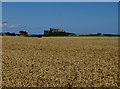
Wheat fields at Saddlershall
Bamburgh Castle is prominent in the distance.
Image: © John Allan
Taken: 17 Aug 2017
0.06 miles
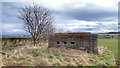
5
Pillbox
Pillbox alongside the lane from Fowberry to Shoreston, with New Shoreston in the background.
Image: © Ian Capper
Taken: 22 Sep 2020
0.06 miles
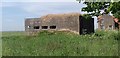
7
WW2 Bunker
A rectangular pillbox, part of the attempt at strengthening this section of the coast during the Second World War against the threat of a German invasion.
Image: © Mick Garratt
Taken: 2 Mar 2015
0.08 miles
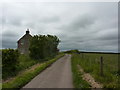
8
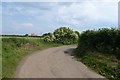
Minor road from Fowberry
A no through road leading to Fowberry Farm.
Image: © DS Pugh
Taken: 1 Jul 2015
0.09 miles
9
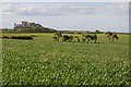
View to Bamburgh Castle
View from the south-east, on St Oswald's Way, to Bamburgh Castle across farmland.
Image: © Philip Halling
Taken: 3 Jun 2015
0.10 miles
10
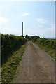
Road approaching Saddlershall
A minor no through road linking with footpaths and bridleways.
Image: © DS Pugh
Taken: 1 Jul 2015
0.12 miles