IMAGES TAKEN NEAR TO
Broad Road Industrial Estate, SEAHOUSES, NE68 7WH
Introduction
This page details the photographs taken nearby to Broad Road Industrial Estate, NE68 7WH by members of the Geograph project.
The Geograph project started in 2005 with the aim of publishing, organising and preserving representative images for every square kilometre of Great Britain, Ireland and the Isle of Man.

There are currently over 7.5m images from over14,400 individuals and you can help contribute to the project by visiting https://www.geograph.org.uk
Image Map
Images are licensed for reuse under creativecommons.org/licenses/by-sa/2.0
Notes
- Clicking on the map will re-center to the selected point.
- The higher the marker number, the further away the image location is from the centre of the postcode.
Image Listing (48 Images Found)
Images are licensed for reuse under creativecommons.org/licenses/by-sa/2.0
Image
Details
Distance
1
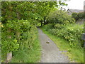
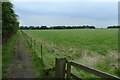
Path on former railway line
The Northumberland Coast Path enters North Sunderland on a disused line.
Image: © Peter Barr
Taken: 22 Jun 2011
0.03 miles
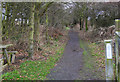
2

Disused railway, Seahouses
A former railway line, now a footpath/cycle path. It provides a spur route into Seahouses off the National Cycle Network route 1. It also provides a good way of avoiding the expensive parking in busy and popular Seahouses.
Image: © Richard Webb
Taken: 20 Aug 2011
0.04 miles
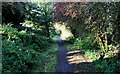
3
Footpath along the old railway trackbed
Image: © Peter Turner
Taken: 23 Dec 2016
0.06 miles
4
Northumberland Coast Path in North Sunderland
The Northumberland Coast Path along with St. Oswald's Way leaves the sea behind temporarily and heads inland on a disused railway trakbed towards North Sunderland.
Image: © Chris Heaton
Taken: 7 Oct 2014
0.06 miles
5
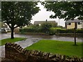
North Lane
Looking across a wet North Lane in North Sunderland.
Image: © DS Pugh
Taken: 10 Aug 2019
0.07 miles
8
Path to St. Aidan's Dunes
A path running from North Sunderland to the coast.
Image: © DS Pugh
Taken: 4 Aug 2019
0.08 miles
9
Course of old railway
Ahead a cycle route has been built on the old railway.
Image: © DS Pugh
Taken: 14 Aug 2013
0.10 miles
10
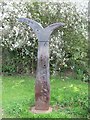
Millennium milepost, North Sunderland
Berwick 28m, Alnmouth 21m. It is situated at the end of the short railway path into Seahouses.
Image: © Richard Webb
Taken: 20 Aug 2011
0.10 miles