IMAGES TAKEN NEAR TO
Main Street, SEAHOUSES, NE68 7TZ
Introduction
This page details the photographs taken nearby to Main Street, NE68 7TZ by members of the Geograph project.
The Geograph project started in 2005 with the aim of publishing, organising and preserving representative images for every square kilometre of Great Britain, Ireland and the Isle of Man.

There are currently over 7.5m images from over14,400 individuals and you can help contribute to the project by visiting https://www.geograph.org.uk
Image Map
Images are licensed for reuse under creativecommons.org/licenses/by-sa/2.0
Notes
- Clicking on the map will re-center to the selected point.
- The higher the marker number, the further away the image location is from the centre of the postcode.
Image Listing (50 Images Found)
Images are licensed for reuse under creativecommons.org/licenses/by-sa/2.0
Image
Details
Distance
1
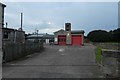
Fire Station
North Sunderland Fire Station on Main Street.
Image: © DS Pugh
Taken: 4 Aug 2019
0.01 miles
2

Seahouses fire station
Seahouses fire station, Main Street, North Sunderland, Seahouses, Northumberland
Image: © Kevin Hale
Taken: 2 Aug 2010
0.02 miles
3
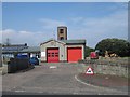
Seahouses Fire Station
Seahouses Community Fire Station, located on Main Street, North Sunderland.
Image: © Graham Robson
Taken: 14 Aug 2012
0.02 miles
4
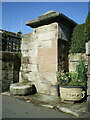
Old water pump to the west of no 132 Main Street
Erected in the early 19th century, and very similar to the Image a little way to the west of here. This one too was Grade II listed https://britishlistedbuildings.co.uk/101276106-old-pump-to-west-of-number-132-north-sunderland#.YV8IKNrMLIU & https://historicengland.org.uk/listing/the-list/list-entry/1276106 in 1969. The circular stone on the ground to the left of the pillar has the look and feel of a plague stone, and if that's the case it would have been used at times of plague/pandemic as a place for residents to leave money in a small quantity of vinegar, to pay for provisions from outside the town.
Image: © Richard Law
Taken: 7 Sep 2021
0.02 miles
5
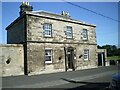
132 Main Street, North Sunderland
This rather fine house was built around 1840 and originally served as the town's police station before being sold off for residential conversion. It attracted a Grade II listing https://britishlistedbuildings.co.uk/101275986-132-main-street-north-sunderland#.YV8L8drMLIU & https://historicengland.org.uk/listing/the-list/list-entry/1275986 in 1969.
Image: © Richard Law
Taken: 7 Sep 2021
0.02 miles
6
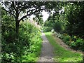
Disused railway, Seahouses
A former railway line, now a footpath/cycle path. It provides a spur route into Seahouses off the National Cycle Network route 1. It also provides a good way of avoiding the expensive parking in busy and popular Seahouses.
Image: © Richard Webb
Taken: 20 Aug 2011
0.07 miles
7
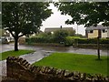
North Lane
Looking across a wet North Lane in North Sunderland.
Image: © DS Pugh
Taken: 10 Aug 2019
0.08 miles
9
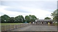
Seahouses Library and Sure Start Centre
The older building to the rear houses the village library branch whilst the more modern timber building in front is utilised as a Sure Start Centre.
Image: © Graham Robson
Taken: 14 Aug 2012
0.09 miles
10
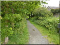
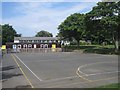
Path on former railway line
The Northumberland Coast Path enters North Sunderland on a disused line.
Image: © Peter Barr
Taken: 22 Jun 2011
0.09 miles