IMAGES TAKEN NEAR TO
Main Street, SEAHOUSES, NE68 7TU
Introduction
This page details the photographs taken nearby to Main Street, NE68 7TU by members of the Geograph project.
The Geograph project started in 2005 with the aim of publishing, organising and preserving representative images for every square kilometre of Great Britain, Ireland and the Isle of Man.

There are currently over 7.5m images from over14,400 individuals and you can help contribute to the project by visiting https://www.geograph.org.uk
Image Map (Loading...)


Getting Data...Please wait
Leaflet Map data © OpenStreetMap
Images are licensed for reuse under creativecommons.org/licenses/by-sa/2.0
Notes
- Clicking on the map will re-center to the selected point.
- The higher the marker number, the further away the image location is from the centre of the postcode.
Image Listing (48 Images Found)
Images are licensed for reuse under creativecommons.org/licenses/by-sa/2.0
Image
Details
Distance
1
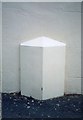
Old Milepost by Main Street, North Sunderland
Cast iron post by the UC road, in parish of NORTH SUNDERLAND (BERWICK UPON TWEED District), Main Street, by No. 161, back of footpath, against house, on South side of road. Chathill iron casting, erected by an unknown authority in the 19th century.
Inscription once read:-
: (CHATHILL / 4 / MILES) : : (PIER HEAD / 1 / MILE) :
Milestone Society National ID: NB_CTSL04.
Image: © IA Davison
Taken: 25 Feb 2008
0.02 miles
2
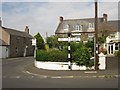
Junction of Main Street and Broad Road, North Sunderland
The junction of two streets in North Sunderland. A pre Worboys road sign and modern bus stop sign are both close to the junction.
Image: © Graham Robson
Taken: 14 Aug 2012
0.03 miles
3
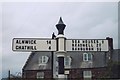
Direction Sign - Signpost, Main Street, North Sunderland
Cone in cup finial - 2 arms; Northumberland wide arm by the UC road, in parish of North Sunderland (Berwick Upon Tweed District), Main Street junction with Broad Road.
Surveyed
Milestone Society National ID: NB_NU2131.
Image: © I Davison
Taken: Unknown
0.03 miles
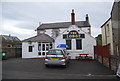
4
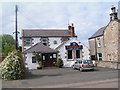
The Lodge Public House, North Sunderland
Image: © N Chadwick
Taken: 30 May 2006
0.04 miles
5

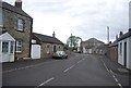
Main Street, North Sunderland
This is the much older settlement than its more famous neighbour, Seahouses
Image: © N Chadwick
Taken: 30 May 2006
0.04 miles
7
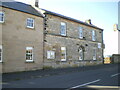
157/159 Main Street, North Sunderland
Ignoring the new (2017) addition to the left, the stone-fronted 2-storey building on the right dates from the late 18th century and was previously a school in the latter part of the 19th. It now serves as a fairly large independent hostel. Grade II listed https://britishlistedbuildings.co.uk/101234769-157-and-159-main-street-north-sunderland#.YUzo7LhKjIU & https://historicengland.org.uk/listing/the-list/list-entry/1234769 in 1987
Image: © Richard Law
Taken: 7 Sep 2021
0.04 miles
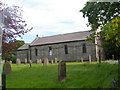
9
The entrance to St Cuthbert's United Reformed Church
Image: © N Chadwick
Taken: 1 Jun 2011
0.05 miles