IMAGES TAKEN NEAR TO
Crown Street, SEAHOUSES, NE68 7TQ
Introduction
This page details the photographs taken nearby to Crown Street, NE68 7TQ by members of the Geograph project.
The Geograph project started in 2005 with the aim of publishing, organising and preserving representative images for every square kilometre of Great Britain, Ireland and the Isle of Man.

There are currently over 7.5m images from over14,400 individuals and you can help contribute to the project by visiting https://www.geograph.org.uk
Image Map (Loading...)


Getting Data...Please wait
Leaflet Map data © OpenStreetMap
Images are licensed for reuse under creativecommons.org/licenses/by-sa/2.0
Notes
- Clicking on the map will re-center to the selected point.
- The higher the marker number, the further away the image location is from the centre of the postcode.
Image Listing (714 Images Found)
Images are licensed for reuse under creativecommons.org/licenses/by-sa/2.0
Image
Details
Distance
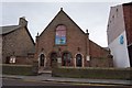
1
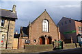
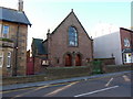
Seahouses Methodist Church
Situated on Main Street.
Image: © Bill Boaden
Taken: 22 May 2013
0.00 miles
2
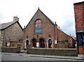
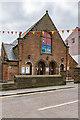
Seahouses Methodist church
Dating from 1925, according to Pevsner.
Image: © Bill Harrison
Taken: 27 Jul 2017
0.01 miles
3
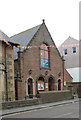
Seahouses : Methodist Church
Built in 1925-1926 to a design by architects Mauchlen and Weightman.
Image: © Jim Osley
Taken: 19 Jun 2018
0.01 miles
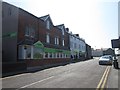
4
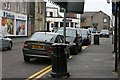
Main Street
No parking restriction largely ignored.
Image: © Mick Garratt
Taken: 5 May 2007
0.02 miles
5
The Co-operative Food, Seahouses
A Co-operative Food supermarket in the village of Seahouses, Northumberland, England.
Image: © Steven Haslington
Taken: 22 Jul 2015
0.02 miles
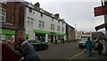
7
The Co-operative Food, Seahouses
The only supermarket in the village, a Co-operative food, located at the junction of Main Street and King Street.
Image: © Graham Robson
Taken: 14 Aug 2012
0.02 miles
8
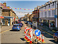
Main Street, Seahouses
Seahouses is a large village on the North Northumberland coast, within the Northumberland Coast Area of Outstanding Natural Beauty. The village now known as Seahouses was originally named Sunderland, then North Sunderland (to distinguish it from the Wearside city of the same name) and was a mile or so inland from the sea. When a purpose-built fishing community was built by the sea it comprised small cottages or ‘sea houses’. With the coming of the railway, two stations were built on the branch line from Chathill. North Sunderland had its own station and the station at the end of the line by the sea was called Seahouses. Thus over the years as the rail-borne tourists spent more time by the sea, the whole community became known by the name Seahouses.
Seahouses attracts many visitors, mainly from the northeast area. However national and international tourists often come to Seahouses whilst visiting the Northumberland National Park, Northumberland Coast and the Farne Islands.
Image: © David Dixon
Taken: 22 May 2021
0.02 miles
10
Seahouses Methodist Church
Methodist Church on Main Street, completed in 1926 with an opening date of 3 July 1926. For a close up of the window in the façade, see Image
Image: © Ian Capper
Taken: 27 May 2021
0.02 miles