IMAGES TAKEN NEAR TO
NE67 5FB
Introduction
This page details the photographs taken nearby to NE67 5FB by members of the Geograph project.
The Geograph project started in 2005 with the aim of publishing, organising and preserving representative images for every square kilometre of Great Britain, Ireland and the Isle of Man.

There are currently over 7.5m images from over14,400 individuals and you can help contribute to the project by visiting https://www.geograph.org.uk
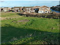
Image Map (94 Images)


Getting Data...Please wait
Leaflet Map data © OpenStreetMap
Images are licensed for reuse under creativecommons.org/licenses/by-sa/2.0
Notes
- Clicking on the map will re-center to the selected point.
- The higher the marker number, the further away the image location is from the centre of the postcode.
Image Listing (94 Images Found)
Images are licensed for reuse under creativecommons.org/licenses/by-sa/2.0
Image
Details
Distance
1
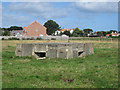
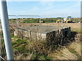
Pillbox in a field, Beadnell
A pillbox, located in a grass field on the edge of Beadnell.
Image: © Graham Robson
Taken: 31 Aug 2013
0.04 miles
2
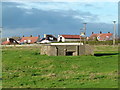
Pillbox at Beadnell
Pre-fabricated type, in a field to the south of the old village centre.
Image: © Alan Murray-Rust
Taken: 25 Dec 2016
0.05 miles
3
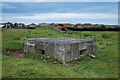
WWII Pillbox (Prefabricated): S0007237, Beadnell
Disused pillbox in a field (Beadnell Green) near the old village of Beadnell in Northumberland
Image: © Jamie Boyd D
Taken: 30 Jul 2020
0.05 miles
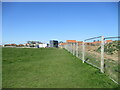
4
Fenced construction area
Construction of new housing called The Kilns in Beadnell.
Image: © DS Pugh
Taken: 26 Jun 2022
0.05 miles
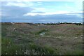
5
WWII pillbox near Beadnell
The site that the pillbox occupies is currently being developed for housing (late 2021) but the box has been fenced off, and will hopefully survive the building work. There was no sign of activity a year or so ago Image
Image: © Richard Law
Taken: 8 Sep 2021
0.05 miles
6

Limekiln at Beadnell
A rather decayed example of the typical Northumbrian sandstone-built kiln, probably from around 1800.
Image: © Alan Murray-Rust
Taken: 25 Dec 2016
0.07 miles
7
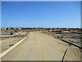
Road into new housing estate being built on greenfield site
Houses at the footings stage
Image: © Martin Dawes
Taken: 22 Apr 2022
0.08 miles
8
Footpath diverted in field around house building site
Image: © Martin Dawes
Taken: 22 Apr 2022
0.08 miles
9
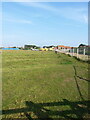
Ridge and furrow in a field southwest of Beadnell
Not quite yet fully destroyed by the extensive house building that's happening just the other side of the fence, this medieval ridge and furrow pattern is clear to see across the field systems here.
Image: © Richard Law
Taken: 8 Sep 2021
0.09 miles
10
The site of Beadnell Colliery
The concrete pad is a cap to the colliery shaft. This was already shown as disused by the middle of the 19th century. The water top right is the flooded limestone quarry which furnished the kilns at Beadnell Harbour.
Image: © Alan Murray-Rust
Taken: 25 Dec 2016
0.09 miles