IMAGES TAKEN NEAR TO
CHATHILL, NE67 5DU
Introduction
This page details the photographs taken nearby to NE67 5DU by members of the Geograph project.
The Geograph project started in 2005 with the aim of publishing, organising and preserving representative images for every square kilometre of Great Britain, Ireland and the Isle of Man.

There are currently over 7.5m images from over14,400 individuals and you can help contribute to the project by visiting https://www.geograph.org.uk
Image Map (Loading...)


Getting Data...Please wait
Leaflet Map data © OpenStreetMap
Images are licensed for reuse under creativecommons.org/licenses/by-sa/2.0
Notes
- Clicking on the map will re-center to the selected point.
- The higher the marker number, the further away the image location is from the centre of the postcode.
Image Listing (7 Images Found)
Images are licensed for reuse under creativecommons.org/licenses/by-sa/2.0
Image
Details
Distance
1
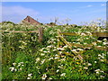
Roadside verge, near Tynely
Tynely is a small Northumbrian hamlet just to the east of the A1 between Belford and Alnwick.
Image: © Lisa Jarvis
Taken: 2 Jun 2007
0.07 miles
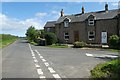
2
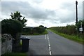
Junction near Tynely
Ahead turns into a bridleway, left goes to Doxford Hall.
Image: © DS Pugh
Taken: 8 Aug 2019
0.11 miles
4
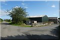
Road at Tynley
Looking along the road (left) which leads towards Ellingham with a farm track to the right.
Image: © DS Pugh
Taken: 8 Aug 2019
0.13 miles
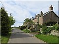
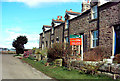
6
Cottages at Tynely
Looking towards the end cottages of a terrace at Tynely.
Image: © DS Pugh
Taken: 8 Aug 2019
0.13 miles
7
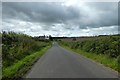
Road to Tynely
Looking along a road leading to Tynely near the A1.
Image: © DS Pugh
Taken: 8 Aug 2019
0.18 miles