IMAGES TAKEN NEAR TO
West End, ALNWICK, NE66 5PP
Introduction
This page details the photographs taken nearby to West End, NE66 5PP by members of the Geograph project.
The Geograph project started in 2005 with the aim of publishing, organising and preserving representative images for every square kilometre of Great Britain, Ireland and the Isle of Man.

There are currently over 7.5m images from over14,400 individuals and you can help contribute to the project by visiting https://www.geograph.org.uk
Image Map
Images are licensed for reuse under creativecommons.org/licenses/by-sa/2.0
Notes
- Clicking on the map will re-center to the selected point.
- The higher the marker number, the further away the image location is from the centre of the postcode.
Image Listing (61 Images Found)
Images are licensed for reuse under creativecommons.org/licenses/by-sa/2.0
Image
Details
Distance
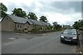
1
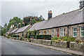
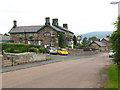
West End
Row of cottages in West End, marked on the 1861 1:2,500 map.
Image: © Ian Capper
Taken: 24 Sep 2020
0.00 miles
2
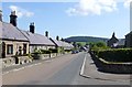
The B6348 through Chatton
A tidy little village with fine pub.
Image: © Russel Wills
Taken: 10 Jun 2015
0.02 miles
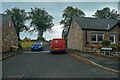
3
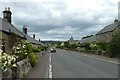
Houses in Chatton
Looking along the B6348 as it passes through the village.
Image: © DS Pugh
Taken: 26 Jun 2022
0.02 miles
5
The Percy Arms, Chatton
A slightly wider view of the hotel than Image As of 2009, it still displayed the Jennings brewery sign but no longer served their beer: the landlord explained it had been taken over by Greene King.
Image: © Stephen Craven
Taken: 28 Jun 2009
0.05 miles
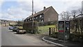
6
Catton : Mill Hill
Looking along Mill Hill off New Road.
Image: © Lewis Clarke
Taken: 22 Sep 2020
0.05 miles
8
Chatton
Outside the Percy Arms. There was a pint in my other hand.
Image: © Richard Webb
Taken: 3 Sep 2017
0.06 miles
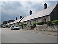
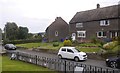
9
Cottages in Chatton
Looking towards Mill Hill in Chatton.
Image: © DS Pugh
Taken: 26 Jun 2022
0.06 miles
10
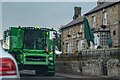
Chatton : New Road B6348
A combine harvester passes along the road.
Image: © Lewis Clarke
Taken: 22 Sep 2020
0.06 miles