IMAGES TAKEN NEAR TO
Whittingham, ALNWICK, NE66 4UT
Introduction
This page details the photographs taken nearby to NE66 4UT by members of the Geograph project.
The Geograph project started in 2005 with the aim of publishing, organising and preserving representative images for every square kilometre of Great Britain, Ireland and the Isle of Man.

There are currently over 7.5m images from over14,400 individuals and you can help contribute to the project by visiting https://www.geograph.org.uk
Image Map
Images are licensed for reuse under creativecommons.org/licenses/by-sa/2.0
Notes
- Clicking on the map will re-center to the selected point.
- The higher the marker number, the further away the image location is from the centre of the postcode.
Image Listing (4 Images Found)
Images are licensed for reuse under creativecommons.org/licenses/by-sa/2.0
Image
Details
Distance
2
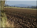
Ploughed field at Yetlington Lane
The Brizlee Wood Radar dome on Alnwick Moor in the distance.
Image: © Russel Wills
Taken: 11 Dec 2013
0.23 miles
3
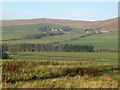
Looking north across the Aln valley
From Yetlington Lane.
Image: © Russel Wills
Taken: 11 Dec 2013
0.24 miles
4
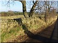
Fine dry stone wall near Yetlington Lane
Pity about the 'hedge' growing in front of it.
Tait's Plantation in the background.
Image: © Russel Wills
Taken: 11 Dec 2013
0.24 miles