IMAGES TAKEN NEAR TO
Thrunton, ALNWICK, NE66 4SD
Introduction
This page details the photographs taken nearby to NE66 4SD by members of the Geograph project.
The Geograph project started in 2005 with the aim of publishing, organising and preserving representative images for every square kilometre of Great Britain, Ireland and the Isle of Man.

There are currently over 7.5m images from over14,400 individuals and you can help contribute to the project by visiting https://www.geograph.org.uk
Image Map
Images are licensed for reuse under creativecommons.org/licenses/by-sa/2.0
Notes
- Clicking on the map will re-center to the selected point.
- The higher the marker number, the further away the image location is from the centre of the postcode.
Image Listing (10 Images Found)
Images are licensed for reuse under creativecommons.org/licenses/by-sa/2.0
Image
Details
Distance
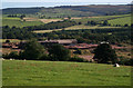
1
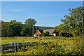
Whittingham : Red House
Looking towards Red House.
Image: © Lewis Clarke
Taken: 21 Sep 2020
0.02 miles
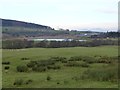
3
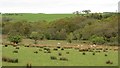
Damp pasture, Learchild Moor
Beside the Coe Burn.
Image: © Richard Webb
Taken: 1 Jun 2013
0.07 miles
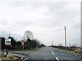
4
Cottage beside the A697
A cottage near the brickworks on Learchild moor.
Image: © James Allan
Taken: 21 Sep 2006
0.07 miles
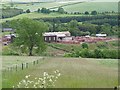
6
Edlingham : Thrunton Brick Works
Looking towards the brickworks in the countryside.
Image: © Lewis Clarke
Taken: 21 Sep 2020
0.09 miles
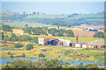
7
Brickworks at Thrunton
Thrunton Wood on the left.
Image: © Russel Wills
Taken: 11 Dec 2013
0.14 miles
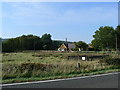
8
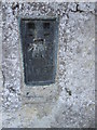
Ordnance Survey Flush Bracket (11267)
This OS Flush Bracket can be found on the east face of the barn at Lear Child Moor House. It marks a point 96.605m above mean sea level.
Image: © Adrian Dust
Taken: 8 Oct 2015
0.14 miles
9
Thrunton Brick Works
Owned and operated by Swarland Brick.
Image: © Oliver Dixon
Taken: 13 Jun 2011
0.15 miles
10
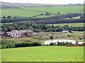
Thrunton Brickworks & clay quarry
The flooded quarry is now home to Thrunton Long Crag Trout Fishery. The fishing lodge can be seen on the right.
Part of the Swarland brickworks, which had been mothballed in 2011, was destroyed in Spetember 2013 in a huge fire which started in a warehouse housing shredded carpet waste.
The brick company was set up in the late 1930s by Commander Vyner to create jobs for the unemployed of Tyneside. In 1942, current managing director Chris Blythe’s grandfather bought the company and the grandson took over in the early 1980s, having worked there since 1972.
At the time of the mothball, Mr Blythe said the company was not selling enough bricks due to the worst building recession since the 1940s. Production had stopped and a total of 4.2 million bricks were sitting on site. A skeleton staff was kept on to sell them.
http://www.chroniclelive.co.uk/news/north-east-news/fire-mothballed-brick-manufacturing-site-5836622
Image: © Andrew Curtis
Taken: 28 Aug 2015
0.15 miles