IMAGES TAKEN NEAR TO
West Lilburn, ALNWICK, NE66 4PP
Introduction
This page details the photographs taken nearby to NE66 4PP by members of the Geograph project.
The Geograph project started in 2005 with the aim of publishing, organising and preserving representative images for every square kilometre of Great Britain, Ireland and the Isle of Man.

There are currently over 7.5m images from over14,400 individuals and you can help contribute to the project by visiting https://www.geograph.org.uk
Image Map
Images are licensed for reuse under creativecommons.org/licenses/by-sa/2.0
Notes
- Clicking on the map will re-center to the selected point.
- The higher the marker number, the further away the image location is from the centre of the postcode.
Image Listing (7 Images Found)
Images are licensed for reuse under creativecommons.org/licenses/by-sa/2.0
Image
Details
Distance
1
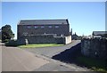
Lilburn Grange
Part of a converted farmstead near Lilburn Tower.
Image: © Stanley Howe
Taken: 23 Sep 2013
0.03 miles
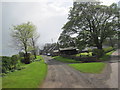
3
Road junction at Lilburn Grange
A lane providing access to the cottages of Lilburn Grange leaving the minor road to the east of Lilburn Tower.
Image: © Graham Robson
Taken: 5 Jul 2015
0.08 miles
4
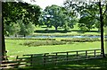
Grassland at Lilburn Grange
Some of the large amount of grassland surrounding Lilburn Grange.
Image: © Graham Robson
Taken: 5 Jul 2015
0.10 miles
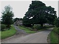
5
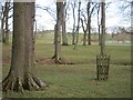
Parkland, Lilburn
View towards the flooded Hurlstone Bog in a kettlehole.
Image: © Richard Webb
Taken: 30 Apr 2013
0.11 miles
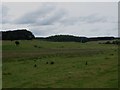
7
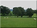
Parkland at Lilburn Tower
Parkland grazed by sheep close to Lilburn Tower.
Image: © Graham Robson
Taken: 5 Jul 2015
0.24 miles