IMAGES TAKEN NEAR TO
Branton, ALNWICK, NE66 4LN
Introduction
This page details the photographs taken nearby to NE66 4LN by members of the Geograph project.
The Geograph project started in 2005 with the aim of publishing, organising and preserving representative images for every square kilometre of Great Britain, Ireland and the Isle of Man.

There are currently over 7.5m images from over14,400 individuals and you can help contribute to the project by visiting https://www.geograph.org.uk
Image Map
Images are licensed for reuse under creativecommons.org/licenses/by-sa/2.0
Notes
- Clicking on the map will re-center to the selected point.
- The higher the marker number, the further away the image location is from the centre of the postcode.
Image Listing (27 Images Found)
Images are licensed for reuse under creativecommons.org/licenses/by-sa/2.0
Image
Details
Distance
2
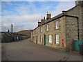
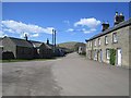
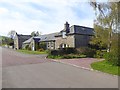
Branton
The terraced cottages divide into Branton Westside on the left, and Eastside on the right. George V postbox NE66 61, shown in Image, can be seen at the right-hand end of the terrace. NCN68 follows this road, turning left at the T junction.
Image: © Derek Harper
Taken: 2 Jan 2020
0.02 miles
4
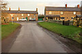
Branton ahead!
In the Breamish valley.
Image: © Russel Wills
Taken: 26 Jul 2012
0.03 miles
5
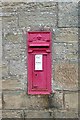
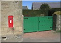
Postbox at Branton
This is a George V postbox (1910-1935).
Image: © Graham Horn
Taken: 3 Sep 2009
0.03 miles
8
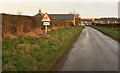
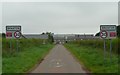
Approaching Branton
The lane carrying NCN68 passes a school sign. The junction ahead is seen in Image
Image: © Derek Harper
Taken: 2 Jan 2020
0.06 miles
10
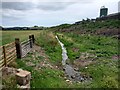
Branton Burn and Farmland
Looks more like a drainage ditch.
Image: © Les Hull
Taken: 18 Jul 2023
0.09 miles