IMAGES TAKEN NEAR TO
Dunstan Village, ALNWICK, NE66 3TB
Introduction
This page details the photographs taken nearby to Dunstan Village, NE66 3TB by members of the Geograph project.
The Geograph project started in 2005 with the aim of publishing, organising and preserving representative images for every square kilometre of Great Britain, Ireland and the Isle of Man.

There are currently over 7.5m images from over14,400 individuals and you can help contribute to the project by visiting https://www.geograph.org.uk
Image Map
Images are licensed for reuse under creativecommons.org/licenses/by-sa/2.0
Notes
- Clicking on the map will re-center to the selected point.
- The higher the marker number, the further away the image location is from the centre of the postcode.
Image Listing (79 Images Found)
Images are licensed for reuse under creativecommons.org/licenses/by-sa/2.0
Image
Details
Distance
1
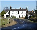
A house in Dunstan
A cosy village a kilometre from Craster and the sea with a comfortable and welcoming inn.
Image: © Russel Wills
Taken: 30 Jan 2015
0.01 miles
2
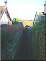
Footpath between houses, Dunstan
A narrowly enclosed footpath down to the Craster road.
Image: © Karl and Ali
Taken: 28 Dec 2013
0.02 miles
3
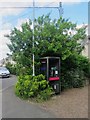
Public telephone box, Dunstan
The public telephone box in the small village of Dunstan.
Image: © Graham Robson
Taken: 31 Aug 2013
0.03 miles
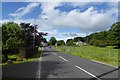
4
Dunstan
Looking along the road through the village of Dunstan.
Image: © DS Pugh
Taken: 30 Jul 2016
0.04 miles
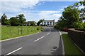
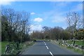
7
Road through Dunstan
Looking towards the Cottage Inn ahead.
Image: © DS Pugh
Taken: 30 Jul 2016
0.06 miles

10
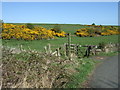
Footpath to Dunstan Square
Off National Cycle Route 1.
Image: © JThomas
Taken: 30 Apr 2015
0.08 miles