IMAGES TAKEN NEAR TO
Burnside, ALNWICK, NE66 3JQ
Introduction
This page details the photographs taken nearby to Burnside, NE66 3JQ by members of the Geograph project.
The Geograph project started in 2005 with the aim of publishing, organising and preserving representative images for every square kilometre of Great Britain, Ireland and the Isle of Man.

There are currently over 7.5m images from over14,400 individuals and you can help contribute to the project by visiting https://www.geograph.org.uk
Image Map
Images are licensed for reuse under creativecommons.org/licenses/by-sa/2.0
Notes
- Clicking on the map will re-center to the selected point.
- The higher the marker number, the further away the image location is from the centre of the postcode.
Image Listing (70 Images Found)
Images are licensed for reuse under creativecommons.org/licenses/by-sa/2.0
Image
Details
Distance
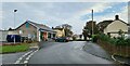
1
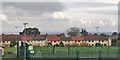
Recreation ground and houses, Longhoughton
Image: © Robin Webster
Taken: 18 Oct 2019
0.02 miles
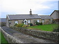
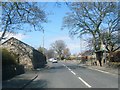
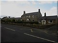
4
Terraced housing, Burnside, Longhoughton
Terraced housing on Burnside in Longhoughton.
Image: © Graham Robson
Taken: 23 Aug 2014
0.04 miles
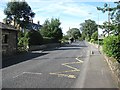
7

Longhoughton store
A hidden gem, on a side-turning from North End in the village of Longhoughton.
Image: © Jonathan Wilkins
Taken: 23 May 2019
0.05 miles
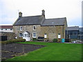
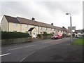
10
Houses in Longhoughton
Traditional stone houses on the main road through the village.
Image: © Graham Robson
Taken: 23 Aug 2014
0.08 miles