IMAGES TAKEN NEAR TO
Springfield Meadow, ALNWICK, NE66 2NY
Introduction
This page details the photographs taken nearby to Springfield Meadow, NE66 2NY by members of the Geograph project.
The Geograph project started in 2005 with the aim of publishing, organising and preserving representative images for every square kilometre of Great Britain, Ireland and the Isle of Man.

There are currently over 7.5m images from over14,400 individuals and you can help contribute to the project by visiting https://www.geograph.org.uk
Image Map
Images are licensed for reuse under creativecommons.org/licenses/by-sa/2.0
Notes
- Clicking on the map will re-center to the selected point.
- The higher the marker number, the further away the image location is from the centre of the postcode.
Image Listing (64 Images Found)
Images are licensed for reuse under creativecommons.org/licenses/by-sa/2.0
Image
Details
Distance
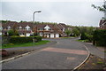
2
Fisher Lane, Alnwick
The houses on the left are on Allerburn Lea.
Image: © habiloid
Taken: 19 Aug 2021
0.06 miles
3
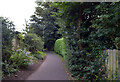
![Urban path [5]](https://s1.geograph.org.uk/geophotos/02/46/13/2461329_84ea5e01_120x120.jpg)
Urban path [5]
A branch of the footpath leads to another part of Allerburn Lea.
Image: © Michael Dibb
Taken: 23 May 2011
0.07 miles
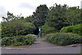
4
To Alnmouth road
From this section of Allerburn Lea, this footpath runs to Alnmouth Road (see Image).
Image: © Michael Dibb
Taken: 23 May 2011
0.07 miles
5
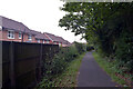
![Urban path [4]](https://s2.geograph.org.uk/geophotos/02/46/13/2461322_fdb0b1ee_120x120.jpg)
Urban path [4]
After crossing Allerburn Lea, the footpath, now surfaced, continues to pass between houses.
Image: © Michael Dibb
Taken: 23 May 2011
0.08 miles
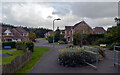
6
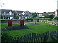
Play park in Allerburn Lea
Viewed from the footpath from Fisher Lane that continues down to the River Aln.
Image: © Russel Wills
Taken: 11 Jun 2012
0.09 miles
7
New housing development on the edge of Alnwick
Image: © Bill Boaden
Taken: 20 May 2013
0.10 miles
8
Path to river leaving Allerburn Lea, Alnwick
Image: © habiloid
Taken: 19 Aug 2021
0.10 miles
10
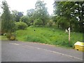
![Urban path [3]](https://s3.geograph.org.uk/geophotos/02/46/12/2461291_2d50e113_120x120.jpg)
Urban path [3]
The footpath crosses the road. The recent housing is built along a series of sinuous roads all called Allerburn Lea.
Image: © Michael Dibb
Taken: 23 May 2011
0.11 miles