IMAGES TAKEN NEAR TO
Clayport Street, ALNWICK, NE66 1LE
Introduction
This page details the photographs taken nearby to Clayport Street, NE66 1LE by members of the Geograph project.
The Geograph project started in 2005 with the aim of publishing, organising and preserving representative images for every square kilometre of Great Britain, Ireland and the Isle of Man.

There are currently over 7.5m images from over14,400 individuals and you can help contribute to the project by visiting https://www.geograph.org.uk
Image Map (Loading...)


Getting Data...Please wait
Leaflet Map data © OpenStreetMap
Images are licensed for reuse under creativecommons.org/licenses/by-sa/2.0
Notes
- Clicking on the map will re-center to the selected point.
- The higher the marker number, the further away the image location is from the centre of the postcode.
Image Listing (437 Images Found)
Images are licensed for reuse under creativecommons.org/licenses/by-sa/2.0
Image
Details
Distance
1
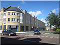
New retail and residential development, Alnwick
A recently completed development in the centre of Alnwick containing shops on the ground floor (mostly still unlet) and residential flats on the upper floors. The shops currently open in the development are Store 21 and Wilkinson.
Image: © Graham Robson
Taken: 28 Aug 2012
0.02 miles
2
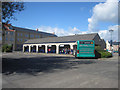
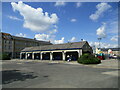
Alnwick Bus Station
The bus station in Alnwick town centre. A Glen Valley Tours bus occupies one of the stops before departing on a 471 service to Wooler.
Image: © Graham Robson
Taken: 28 Aug 2012
0.04 miles
3
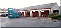
Alnwick Bus Station
Only one Bus on station when I was there.
Image: © David Clark
Taken: 4 Dec 2009
0.04 miles
4
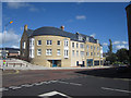
New residential and retail development, Alnwick
This new development in Alnwick town centre includes retail space on the ground floor (much of it still unlet 12 months after the buildings completion) and a large number of flats on the upper floors.
Image: © Graham Robson
Taken: 28 Aug 2012
0.04 miles
5
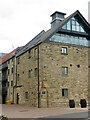
'The Maltings', Alnwick
The Alnwick Brewery Company first started brewing beer in the centre of Alnwick in the 1860s. The brewery was eventually sold in 1978 to the Scottish brewers Dryboroughs who, in turn, closed down the brewery in 1986. It has now been redeveloped, utilising some of the original buildings, for housing purposes.
Image: © Geoff Holland
Taken: 1 Oct 2020
0.05 miles
8
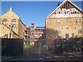
Work halted
Building work on the Malthouse development, off Dispensary Street in Alnwick, was suspended in 2009 because of a downturn in the housing market. The £6 million renovation of The Maltings and grade two listed Bolam's Mill with a total of 33 two and three-bedroom apartments and five offices were planned for the site, linking the two buildings with a central atrium.
Image: © Michael Dibb
Taken: 22 May 2011
0.05 miles
9
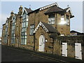
Former Anglican Mission Hall, New Row, Pottersgate
Described in the 1992 edition of Nikolaus Pevsner's book, 'Northumberland (The Buildings of England)' as, "tucked away off the south side of Pottersgate", this fine building by F. R. Wilson dates to 1886 and is Grade II Listed. Originally built as an Anglican Mission Hall ("The poor man's parish church, with soup kitchens etc. below a first-floor hall") it was for many years occupied by H. C. Coates & Son, Printers, before, eventually, being converted into flats. The editors of the 1992 edition of Pevsner's book thought that there was, "plenty of fussy but cheaply done detail to the timber-framed canted bays on each side", although, in conclusion, considered the building to be, "an interesting piece of social history".
Image: © Geoff Holland
Taken: 28 Oct 2020
0.06 miles
10
Road into Alnwick
The B6341 from Rothbury.
Image: © Trevor Harris
Taken: 26 Oct 2011
0.08 miles