1
Impounded!
Alnwick's Pinfold. Moved to this site in 1819.
Image: © Jonathan Thacker
Taken: 20 May 2012
0.03 miles
2
Alnwick Pinfold
Used to impound stray livestock. Owners were levied a fine to redeem their animals. Descriptive plaque http://www.geograph.org.uk/photo/5560888
Currently used as a car park, a camper van is hiding in it here!
Image: © Russel Wills
Taken: 5 Oct 2017
0.03 miles
3
Plaque on Alnwick Pinfold
To see the pinfold http://www.geograph.org.uk/photo/5560887
Image: © Russel Wills
Taken: 5 Oct 2017
0.03 miles
4
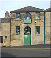
Old Warehouse, Hotspur Street, Alnwick
Image: © Geoff Holland
Taken: 7 Jun 2021
0.03 miles
5
Alnwick : Warehouse
Image: © Jim Osley
Taken: 15 Jun 2018
0.04 miles
6
The Old School House, Green Batt, Alnwick
The house was originally built as the school house for the adjoining Duke of Northumberland’s Jubilee School, which was founded by the 2nd Duke of Northumberland to celebrate the Golden Jubilee of King George III and to provide elementary education for 200 poor boys. It was opened in 1811 and eventually became known simply as the 'Duke’s School’ moving to a new site in 1904.
Image: © Geoff Holland
Taken: 24 May 2021
0.04 miles
7
The Tanners Arms, 2 Hotspur Place, Alnwick
Together with numbers 4 & 6 Hotspur Place, the Tanners Arms is a Grade II Listed Building. This early 19th century building has a curved corner, with one window to Hotspur Street, and which, at roof level, has a raised panel with a moulded capping inscribed with the name, 'Brewers' Arms'.
Image: © Geoff Holland
Taken: 24 May 2021
0.05 miles
8
Hotspur Street
Hotspur Street offers an opportunity for traffic to avoid the busy Bondgate and the pinch-point formed by Bondgate Tower.
Image: © Oliver Dixon
Taken: 8 Aug 2018
0.05 miles
9
Fake Horse Head, Bondgate Within, Alnwick
Attached to the exterior of Jobson's of Alnwick, which sells country clothing and saddles, this fake head is in an eye-catching location next to Bondgate Tower, a 15th century stone three storey gatehouse.
Image: © Geoff Holland
Taken: 24 May 2021
0.05 miles
10
Swabbing the decks!
Mopping up at the festival before the dancers commence Summer 2008!
Image: © Steve Fareham
Taken: 2 Aug 2008
0.06 miles


