IMAGES TAKEN NEAR TO
Old School Close, ALNWICK, NE66 1FH
Introduction
This page details the photographs taken nearby to Old School Close, NE66 1FH by members of the Geograph project.
The Geograph project started in 2005 with the aim of publishing, organising and preserving representative images for every square kilometre of Great Britain, Ireland and the Isle of Man.

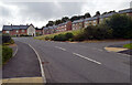
There are currently over 7.5m images from over14,400 individuals and you can help contribute to the project by visiting https://www.geograph.org.uk
Image Map
Images are licensed for reuse under creativecommons.org/licenses/by-sa/2.0
Notes
- Clicking on the map will re-center to the selected point.
- The higher the marker number, the further away the image location is from the centre of the postcode.
Image Listing (123 Images Found)
Images are licensed for reuse under creativecommons.org/licenses/by-sa/2.0
Image
Details
Distance
1
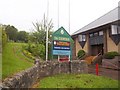
TA Centre sign
The sign details the organizations using the TA Centre in Lisburn Terrace.
Image: © Michael Dibb
Taken: 28 May 2011
0.04 miles
2
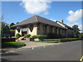
Territorial Army Centre, Alnwick
The Territorial Army Centre is located on Lisburn Terrace, Alnwick.
Image: © Graham Robson
Taken: 28 Aug 2012
0.04 miles
3
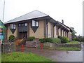
TA Centre
This building on Lisburn Terrace replaces the one in Fenkle Street. See Image
Image: © Michael Dibb
Taken: 28 May 2011
0.05 miles
4
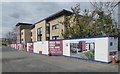
Beech Tree House Care Home
Somewhat delayed! Signs on the hoarding say 'Opening by Spring 2018', 'Opening by Spring 2019' and it is still not open by spring 2020!
https://www.prestwickcare.co.uk/alnwick-care-home/
Image: © Russel Wills
Taken: 31 Mar 2020
0.06 miles
5
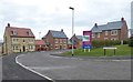
St John's Place, Alnwick
Developed as a continuation of Willoughby Park this now appears complete.
https://www.cussins.com/development/st-johns-place-alnwick/
Image: © Russel Wills
Taken: 31 Mar 2020
0.06 miles
6
Site of former bus depot, Lisburn Street, Alnwick
The site of the former Arriva (and its various predecessors) bus depot in Alnwick. The large bus shed has been demolished and is awaiting a new development.
Image: © Graham Robson
Taken: 11 Jul 2015
0.07 miles
7
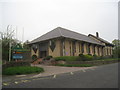
Territorial Army Centre
A suitably bunker-like building. It dates form 1983 and was designed by Frank Harrison.
Image: © Jonathan Thacker
Taken: 21 May 2012
0.07 miles
9
Willoughby Park
This development appears to have filled the space available.
See how it looked 6 years ago: https://www.geograph.org.uk/photo/3903520
Image: © Russel Wills
Taken: 31 Mar 2020
0.09 miles