IMAGES TAKEN NEAR TO
Chapel Lands, ALNWICK, NE66 1ES
Introduction
This page details the photographs taken nearby to Chapel Lands, NE66 1ES by members of the Geograph project.
The Geograph project started in 2005 with the aim of publishing, organising and preserving representative images for every square kilometre of Great Britain, Ireland and the Isle of Man.

There are currently over 7.5m images from over14,400 individuals and you can help contribute to the project by visiting https://www.geograph.org.uk
Image Map (Loading...)


Getting Data...Please wait
Leaflet Map data © OpenStreetMap
Images are licensed for reuse under creativecommons.org/licenses/by-sa/2.0
Notes
- Clicking on the map will re-center to the selected point.
- The higher the marker number, the further away the image location is from the centre of the postcode.
Image Listing (57 Images Found)
Images are licensed for reuse under creativecommons.org/licenses/by-sa/2.0
Image
Details
Distance
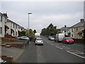
1
Clayport Bank, Alnwick
A well placed bench on quite a long hill.
Image: © Richard Webb
Taken: 11 Oct 2024
0.05 miles
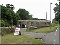
4
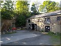
In the quarry?
This building abuts the rock face and seems to have been built in a disused quarry. Seen from the B6341 road.
Image: © Michael Dibb
Taken: 24 May 2011
0.07 miles
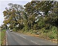
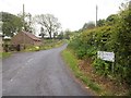
5
Clayport Bank, Alnwick
The Rothbury road at the junction with The Battlements, the road to the golf club.
Image: © Richard Webb
Taken: 11 Oct 2024
0.07 miles
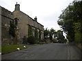
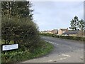
6
A road named Battlements
This oddly named road is seen at its junction with the B6341 at the top of Willoughby's Bank.
Image: © Michael Dibb
Taken: 28 May 2011
0.07 miles
7
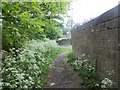
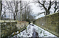
Down Willoughby's Bank [1]
The footpath runs alongside this wall that surrounds Swansfield House.
Image: © Michael Dibb
Taken: 28 May 2011
0.08 miles
8
Path along walled lane descending into Alnwick
The walled lane runs almost parallel with the B6341 as both descend into the town. Gradually they converge and come alongside each other, but remain separate until well into the built up area.
Image: © Trevor Littlewood
Taken: 9 Mar 2023
0.08 miles
9
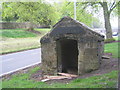
Stone Hut on Clayport Bank
What was its purpose?
Image: © Jonathan Thacker
Taken: 21 May 2012
0.09 miles