IMAGES TAKEN NEAR TO
Whitefield Terrace, NEWCASTLE UPON TYNE, NE6 5SS
Introduction
This page details the photographs taken nearby to Whitefield Terrace, NE6 5SS by members of the Geograph project.
The Geograph project started in 2005 with the aim of publishing, organising and preserving representative images for every square kilometre of Great Britain, Ireland and the Isle of Man.

There are currently over 7.5m images from over14,400 individuals and you can help contribute to the project by visiting https://www.geograph.org.uk
Image Map
Images are licensed for reuse under creativecommons.org/licenses/by-sa/2.0
Notes
- Clicking on the map will re-center to the selected point.
- The higher the marker number, the further away the image location is from the centre of the postcode.
Image Listing (18 Images Found)
Images are licensed for reuse under creativecommons.org/licenses/by-sa/2.0
Image
Details
Distance
1
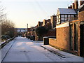
Back Alley behind Whitefield Terrace, Heaton, Newcastle
One of the many back alleys that run through the suburb of Heaton in the east end of Newcastle.
Image: © Andrew Tryon
Taken: 7 Feb 2007
0.01 miles
2
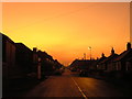
Fiery Orange Sky over Newcastle upon Tyne
An unusually intense colour to the sky over the east end of Newcastle upon Tyne on a winter evening in 2008. The photograph has not been enhanced; the colour is genuine.
Image: © Andrew Tryon
Taken: 18 Feb 2008
0.05 miles
3
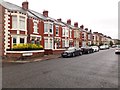
Cartington Terrace, Heaton, Newcastle upon Tyne
A residential street in Heaton. Like much of Heaton the housing stock consists of Tyneside flats.
Image: © Graham Robson
Taken: 12 Jun 2020
0.07 miles
4
Play area, Iris Brickfield Park, Newcastle upon Tyne
An area containing swings and other assorted play equipment in Iris Brickfield Park in Heaton.
Image: © Graham Robson
Taken: 12 Jun 2020
0.08 miles
5
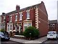
End of the Terrace
Terraced housing in Heaton, much of which is now let to students.
Image: © Graham Hogg
Taken: 5 Jun 2004
0.12 miles
6
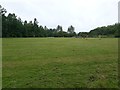
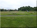
Playing field, Iris Brickfield Park, Newcastle upon Tyne
An area of flat ground in Iris Brickfield Park containing a pair of rusting football goals.
Image: © Graham Robson
Taken: 12 Jun 2020
0.14 miles
7
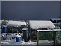
Iris Brickfield allotments
Just before the snow broke the roof
Image: © Dave Shepherdson
Taken: 27 Nov 2010
0.15 miles
8
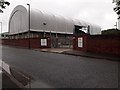
Colas maintenance depot, Rothbury Terrace, Newcastle upon Tyne
A depot for highway maintenance contractors on Rothbury Terrace. The large building contains a stockpile of road salt for use on the city's roads. The gritters based here carry out road gritting across the city on behalf of the city council.
Image: © Graham Robson
Taken: 12 Jun 2020
0.18 miles
9
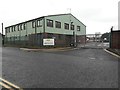
Colas offices, Rothbury Terrace, Heaton, Newcastle upon Tyne
The Newcastle office of the national infrastructure construction and maintenance business. The site was formerly a base for the city council.
Image: © Graham Robson
Taken: 12 Jun 2020
0.18 miles
10
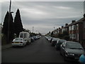
Addycombe Terrace (Facing South)
Possibly the longest predominantly residential street in Newcastle's East End. Post-war semis and bungalows to the North, C.19 Tyneside Terracing to South.
Image: © MSX
Taken: 9 Oct 2005
0.19 miles