IMAGES TAKEN NEAR TO
Felton, MORPETH, NE65 9QF
Introduction
This page details the photographs taken nearby to NE65 9QF by members of the Geograph project.
The Geograph project started in 2005 with the aim of publishing, organising and preserving representative images for every square kilometre of Great Britain, Ireland and the Isle of Man.

There are currently over 7.5m images from over14,400 individuals and you can help contribute to the project by visiting https://www.geograph.org.uk
Image Map (Loading...)


Getting Data...Please wait
Leaflet Map data © OpenStreetMap
Images are licensed for reuse under creativecommons.org/licenses/by-sa/2.0
Notes
- Clicking on the map will re-center to the selected point.
- The higher the marker number, the further away the image location is from the centre of the postcode.
Image Listing (5 Images Found)
Images are licensed for reuse under creativecommons.org/licenses/by-sa/2.0
Image
Details
Distance
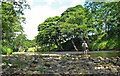
1
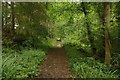
Footpath in Park Wood
A footpath in Park Wood to the west of Felton. This path is used by St Oswald's Way long distance path as sticks close to the northern bank of the River Coquet west of Felton.
Image: © Graham Robson
Taken: 21 Jul 2018
0.16 miles
2
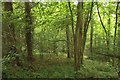
Trees in Park Wood
Looking between the trees in Park Wood. The ground slopes away to the River Coquet which is out of view beyond the vegetation.
Image: © Graham Robson
Taken: 21 Jul 2018
0.16 miles
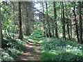
4
Woodland path following the River Coquet
The path heads through the woodland on top of the steep banks on the N side of the river, and is on the route of St Oswald's Way.
Image: © Jim Barton
Taken: 28 Feb 2015
0.21 miles
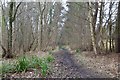
5
River Coquet at Shothaugh
The River Coquet near Shothaugh, at summer level and on a bright day, provides an extremely testing prospect for a seatrout fisherman.
Image: © Roger Lombard
Taken: 23 Jul 2010
0.25 miles