IMAGES TAKEN NEAR TO
Newton-on-the-Moor, MORPETH, NE65 9LW
Introduction
This page details the photographs taken nearby to NE65 9LW by members of the Geograph project.
The Geograph project started in 2005 with the aim of publishing, organising and preserving representative images for every square kilometre of Great Britain, Ireland and the Isle of Man.

There are currently over 7.5m images from over14,400 individuals and you can help contribute to the project by visiting https://www.geograph.org.uk
Image Map (Loading...)


Getting Data...Please wait
Leaflet Map data © OpenStreetMap
Images are licensed for reuse under creativecommons.org/licenses/by-sa/2.0
Notes
- Clicking on the map will re-center to the selected point.
- The higher the marker number, the further away the image location is from the centre of the postcode.
Image Listing (5 Images Found)
Images are licensed for reuse under creativecommons.org/licenses/by-sa/2.0
Image
Details
Distance
1
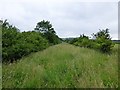
Public bridleway heading for Newton Low Steads Farm
The farm is just visible above the long grass covering the bridleway.
Image: © Russel Wills
Taken: 22 Jul 2013
0.07 miles
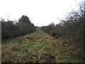
3
Ford and footbridge over Newton Burn
On the approach to Newton Low Steads Farm
which is just visible through the trees.
Image: © Russel Wills
Taken: 22 Jul 2013
0.10 miles
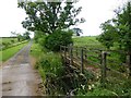
4
Ford at Newton on the Moor
This irish bridge ford on the Newton Burn is found on the approach to Newton Low Steads Farm.
Image: © John Walton
Taken: 7 May 2014
0.11 miles
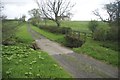
5
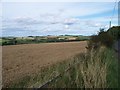
The view
Looking NorthEast from the Chesterhill junction.Towards Shilbottle in the distance.
Image: © David Clark
Taken: 7 Sep 2009
0.12 miles