IMAGES TAKEN NEAR TO
Newton-on-the-Moor, MORPETH, NE65 9LE
Introduction
This page details the photographs taken nearby to NE65 9LE by members of the Geograph project.
The Geograph project started in 2005 with the aim of publishing, organising and preserving representative images for every square kilometre of Great Britain, Ireland and the Isle of Man.

There are currently over 7.5m images from over14,400 individuals and you can help contribute to the project by visiting https://www.geograph.org.uk
Image Map
Images are licensed for reuse under creativecommons.org/licenses/by-sa/2.0
Notes
- Clicking on the map will re-center to the selected point.
- The higher the marker number, the further away the image location is from the centre of the postcode.
Image Listing (9 Images Found)
Images are licensed for reuse under creativecommons.org/licenses/by-sa/2.0
Image
Details
Distance
3
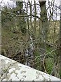
Newton Burn
About to go under a bridge on the old A1.
Image: © Russel Wills
Taken: 24 Apr 2013
0.12 miles
4
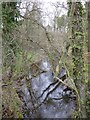
Newton Burn
Between the old and new A1.
Near Newton Low Hall.
Image: © Russel Wills
Taken: 24 Apr 2013
0.14 miles
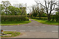
5
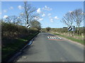
Leaving Newton on the Moor
Heading north on what was once the A1. (The village is now by-passed by a dual carriageway).
Image: © JThomas
Taken: 17 Apr 2015
0.14 miles
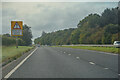
6
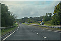
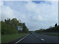
Newton on The Moor : A1
Looking south on the A1.
Image: © Lewis Clarke
Taken: 25 Sep 2020
0.20 miles
7
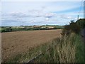
The view
Looking NorthEast from the Chesterhill junction.Towards Shilbottle in the distance.
Image: © David Clark
Taken: 7 Sep 2009
0.21 miles
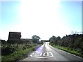
9
Newton on The Moor : A1
Looking south on the A1.
Image: © Lewis Clarke
Taken: 25 Sep 2020
0.24 miles