IMAGES TAKEN NEAR TO
East Thirston, MORPETH, NE65 9EJ
Introduction
This page details the photographs taken nearby to NE65 9EJ by members of the Geograph project.
The Geograph project started in 2005 with the aim of publishing, organising and preserving representative images for every square kilometre of Great Britain, Ireland and the Isle of Man.

There are currently over 7.5m images from over14,400 individuals and you can help contribute to the project by visiting https://www.geograph.org.uk
Image Map
Images are licensed for reuse under creativecommons.org/licenses/by-sa/2.0
Notes
- Clicking on the map will re-center to the selected point.
- The higher the marker number, the further away the image location is from the centre of the postcode.
Image Listing (8 Images Found)
Images are licensed for reuse under creativecommons.org/licenses/by-sa/2.0
Image
Details
Distance

2

East Thirston village
On higher ground south of the River Coquet.
Image: © Russel Wills
Taken: 31 Jul 2013
0.02 miles

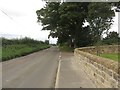
4

East Thirston
B6345 on the way to Felton.
Image: © Richard Webb
Taken: 15 May 2015
0.04 miles
5
Road through East Thirston
Looking along the road which passes through the small hamlet of East Thirston.
Image: © Graham Robson
Taken: 27 Aug 2017
0.05 miles
6

Crop under netting, East Thirston
No idea what was growing under there.
Image: © Richard Webb
Taken: 15 May 2015
0.06 miles
7
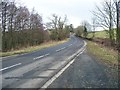
The road to East Thirston
From the bridge at Thirston Mill over the Thirston Burn.
Image: © David Clark
Taken: 11 Feb 2010
0.20 miles
8

A field of potatoes
East of East Thirston.
Image: © Russel Wills
Taken: 31 Jul 2013
0.22 miles