IMAGES TAKEN NEAR TO
Wingates, MORPETH, NE65 8RW
Introduction
This page details the photographs taken nearby to NE65 8RW by members of the Geograph project.
The Geograph project started in 2005 with the aim of publishing, organising and preserving representative images for every square kilometre of Great Britain, Ireland and the Isle of Man.

There are currently over 7.5m images from over14,400 individuals and you can help contribute to the project by visiting https://www.geograph.org.uk
Image Map (Loading...)


Getting Data...Please wait
Leaflet Map data © OpenStreetMap
Images are licensed for reuse under creativecommons.org/licenses/by-sa/2.0
Notes
- Clicking on the map will re-center to the selected point.
- The higher the marker number, the further away the image location is from the centre of the postcode.
Image Listing (12 Images Found)
Images are licensed for reuse under creativecommons.org/licenses/by-sa/2.0
Image
Details
Distance
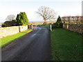
1
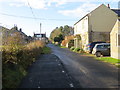
Minor road in Wingates
Looking south-westward from near the Village Hall.
Image: © Peter Wood
Taken: 8 Dec 2018
0.02 miles
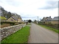
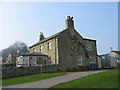
3

Houses in Wingates
An attractive well-kept village.
Image: © Russel Wills
Taken: 22 Aug 2014
0.06 miles
4

East Wingates Farm Butchery
At the end of the road in Wingates.
Image: © Russel Wills
Taken: 22 Aug 2014
0.09 miles
5
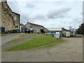
East Wingates Farm Butchery
Farm-based butchery business.
Image: © Oliver Dixon
Taken: 18 Apr 2018
0.09 miles
7
Minor road comes to an end at East Wingates Farm
Looking north-eastward.
Image: © Peter Wood
Taken: 8 Dec 2018
0.11 miles
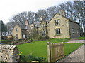
9
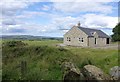
New house at Wingates
With view north over Coquetdale.
Image: © Russel Wills
Taken: 22 Aug 2014
0.13 miles
10
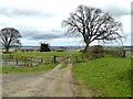
Bridleway to Todburn
Continuation of the road into Wingates village.
Image: © Oliver Dixon
Taken: 18 Apr 2018
0.14 miles