IMAGES TAKEN NEAR TO
Wingates, MORPETH, NE65 8RR
Introduction
This page details the photographs taken nearby to NE65 8RR by members of the Geograph project.
The Geograph project started in 2005 with the aim of publishing, organising and preserving representative images for every square kilometre of Great Britain, Ireland and the Isle of Man.

There are currently over 7.5m images from over14,400 individuals and you can help contribute to the project by visiting https://www.geograph.org.uk
Image Map (Loading...)


Getting Data...Please wait
Leaflet Map data © OpenStreetMap
Images are licensed for reuse under creativecommons.org/licenses/by-sa/2.0
Notes
- Clicking on the map will re-center to the selected point.
- The higher the marker number, the further away the image location is from the centre of the postcode.
Image Listing (7 Images Found)
Images are licensed for reuse under creativecommons.org/licenses/by-sa/2.0
Image
Details
Distance
1

Wholme Gill Head Plantation clear felled
Finally reaping the dubious benefit of Storm Arwen some 18 months on, in a short section of the Tod Burn (on old maps) valley.
Image: © Leanmeanmo
Taken: 21 Aug 2023
0.10 miles
2

Storm Arwen at Fiddler's Elbow
Everywhere one goes in mid and north Northumberland one sees the consequences of Storm Arwen's ferocity in swathes of fallen trees. On November 26th 2021 the storm is estimated to have damaged 16 million trees: the Great Storm of 1987 destroyed 15 million trees.
Image: © Leanmeanmo
Taken: 1 Apr 2022
0.10 miles
3
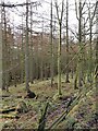
Plantation near Wingates Wholme
Along a tributary of the Ray Burn.
Image: © Oliver Dixon
Taken: 8 Feb 2011
0.12 miles

5

Wholme Gill
Near Fiddler's Elbow.
Providing low maintenance drinking water for cattle!
Image: © Russel Wills
Taken: 22 Aug 2014
0.21 miles
6

Pasture beside Wholme Gill
Geordie Bell Plantation in the distance.
Image: © Russel Wills
Taken: 22 Aug 2014
0.21 miles
7

The Ray Burn near Wingates Wholme
A tributary of the Coquet, alternately known as the Todd Burn,
Image: © Oliver Dixon
Taken: 8 Feb 2011
0.23 miles