IMAGES TAKEN NEAR TO
Longframlington, MORPETH, NE65 8JR
Introduction
This page details the photographs taken nearby to NE65 8JR by members of the Geograph project.
The Geograph project started in 2005 with the aim of publishing, organising and preserving representative images for every square kilometre of Great Britain, Ireland and the Isle of Man.

There are currently over 7.5m images from over14,400 individuals and you can help contribute to the project by visiting https://www.geograph.org.uk
Image Map (Loading...)


Getting Data...Please wait
Leaflet Map data © OpenStreetMap
Images are licensed for reuse under creativecommons.org/licenses/by-sa/2.0
Notes
- Clicking on the map will re-center to the selected point.
- The higher the marker number, the further away the image location is from the centre of the postcode.
Image Listing (10 Images Found)
Images are licensed for reuse under creativecommons.org/licenses/by-sa/2.0
Image
Details
Distance
1
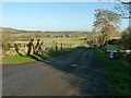
Track to Thorneyhaugh
Thorneyhaugh appears to have been given a standard Local Authority place name sign, but is simply a large farmstead.
Image: © Alan Murray-Rust
Taken: 28 Dec 2016
0.13 miles
2

Primrose and Blue Violets
These were found in a moist area shade by tree cover. The narrow road on a steep, almost hairpin bend, added to the challenge of taking this photograph.
Image: © David Clark
Taken: 12 May 2010
0.16 miles
4
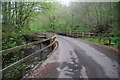
The Footbridge over the Forestburn at Pauperhaugh.
The Footbridge for use when the Ford is full, and other times too, of course.
Image: © David Clark
Taken: 18 Sep 2009
0.19 miles
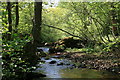
5
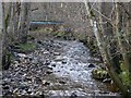
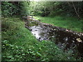
Forest Burn
Looking upstream from the road bridge near Bushygap.
Image: © Paul Franks
Taken: 23 May 2012
0.19 miles
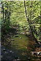
6
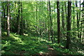
Woodland near East Raw
The Forest Burn flows through this woodland downstream of The Lee.
Image: © Paul Franks
Taken: 23 May 2012
0.19 miles
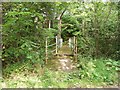
7
Footbridge over the Forest Burn
Near Butterknowes.
Image: © Russel Wills
Taken: 30 Mar 2013
0.19 miles
8
Footbridge over Forest Burn
The burn soon joins the River Coquet.
Image: © Russel Wills
Taken: 14 Feb 2015
0.19 miles
9
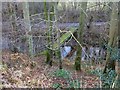
Ford at Bushygap
This substantial irish bridge ford is found at Bushygap.
Image: © John Walton
Taken: 5 May 2014
0.21 miles
10
The Forest Burn
The footpath crosses this stream at this point, but it is difficult to cross after a lot of rain! In the distance is a pipeline and sheep fence.
Image: © Dean Allison
Taken: 31 Aug 2015
0.23 miles