IMAGES TAKEN NEAR TO
The Paddock, MORPETH, NE65 8EU
Introduction
This page details the photographs taken nearby to The Paddock, NE65 8EU by members of the Geograph project.
The Geograph project started in 2005 with the aim of publishing, organising and preserving representative images for every square kilometre of Great Britain, Ireland and the Isle of Man.

There are currently over 7.5m images from over14,400 individuals and you can help contribute to the project by visiting https://www.geograph.org.uk
Image Map (Loading...)


Getting Data...Please wait
Leaflet Map data © OpenStreetMap
Images are licensed for reuse under creativecommons.org/licenses/by-sa/2.0
Notes
- Clicking on the map will re-center to the selected point.
- The higher the marker number, the further away the image location is from the centre of the postcode.
Image Listing (6 Images Found)
Images are licensed for reuse under creativecommons.org/licenses/by-sa/2.0
Image
Details
Distance
4
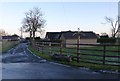
Drive to North End Dairy
On the outskirts of Longframlington.
Image: © Russel Wills
Taken: 26 Dec 2013
0.16 miles
5
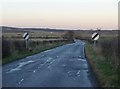
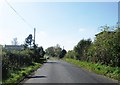
Leaving Longframlington
Heading north towards Alnwick.
Image: © Russel Wills
Taken: 26 Dec 2013
0.17 miles
6
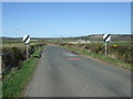
Minor road towards Swarland
Heading north east.
Image: © JThomas
Taken: 17 Apr 2015
0.17 miles