IMAGES TAKEN NEAR TO
Front Street, MORPETH, NE65 8DH
Introduction
This page details the photographs taken nearby to Front Street, NE65 8DH by members of the Geograph project.
The Geograph project started in 2005 with the aim of publishing, organising and preserving representative images for every square kilometre of Great Britain, Ireland and the Isle of Man.

There are currently over 7.5m images from over14,400 individuals and you can help contribute to the project by visiting https://www.geograph.org.uk
Image Map
Images are licensed for reuse under creativecommons.org/licenses/by-sa/2.0
Notes
- Clicking on the map will re-center to the selected point.
- The higher the marker number, the further away the image location is from the centre of the postcode.
Image Listing (107 Images Found)
Images are licensed for reuse under creativecommons.org/licenses/by-sa/2.0
Image
Details
Distance
1
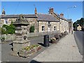
Coronation drinking fountain, Longframlington
No longer dispensing drinking water, this fountain is inscribed "George V and Queen Mary, June 22nd 1911." The busy A697 from Morpeth to Coldstream and south-east Scotland runs along the main street of the village.
Image: © Oliver Dixon
Taken: 24 Jun 2011
0.01 miles
2
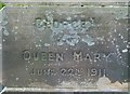
Inscription on the Lion fountain, Longframlington
See http://www.geograph.org.uk/photo/5244375 for location.
Image: © Alan Murray-Rust
Taken: 28 Dec 2016
0.01 miles
3
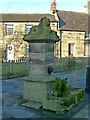
Lion fountain, Longframlington
On the corner of Front Street and Church Street. It commemorates the Coronation of King George V and Queen Mary in 1911 and is Listed Grade II.
The houses behind (Lion House to the left, dated 1783, and Kielland to the right) are late 18th century and also Listed Grade II, for group value.
Image: © Alan Murray-Rust
Taken: 28 Dec 2016
0.01 miles
4
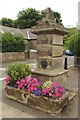
Pant, Front Street, Longframlington
A pant on the corner of Front Street (the A697) and Church Street in Longframlington. The Grade II listed Pant was erected to commemorate the coronation of King George V and Queen Mary in 1911. The inscription on the pant can be seen here: Image and the Historic England record can be seen here: https://historicengland.org.uk/listing/the-list/list-entry/1041853
Image: © Graham Robson
Taken: 21 Jul 2018
0.01 miles
5
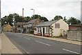
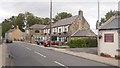
Front Street, Longframlington
Front Street also carries the A697 road through the village. In the picture here is the village butcher's shop and one of the village's pubs.
Image: © Graham Robson
Taken: 21 Jul 2018
0.01 miles
6
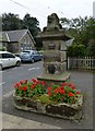
Pant on Junction of Front Street with Church Street, Longframlington
Dated 1911, to commemorate Coronation. Cut stone. Rusticated square shaft
on moulded plinth carrying moulded cap with lion couchant; above tap (removed)
on shaft is inscription 'GEORGE V AND QUEEN MARY JUNE 22ND 1911'. Monolithic
stone trough with rounded ends, now capped over.
http://www.britishlistedbuildings.co.uk/en-236823-pant-on-north-of-junction-with-church-st
Image: © Russel Wills
Taken: 3 Sep 2014
0.02 miles
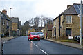
7
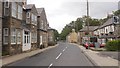
Front Street, Longframlington
The A697.
Image: © Richard Webb
Taken: 15 Sep 2018
0.02 miles
8
Front Street, Longframlington
The A697 trunk road passing through the village.
Image: © Alan Murray-Rust
Taken: 28 Dec 2016
0.02 miles
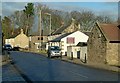
9
The Granby Inn
Front Street (A697), Longframlington.
Image: © Richard Webb
Taken: 15 Sep 2018
0.02 miles
10
Front Street, Longframlington
The A697 towards Wooler and Coldstream.
Image: © Robin Webster
Taken: 23 Dec 2019
0.02 miles