IMAGES TAKEN NEAR TO
Rimside Gardens, MORPETH, NE65 8DE
Introduction
This page details the photographs taken nearby to Rimside Gardens, NE65 8DE by members of the Geograph project.
The Geograph project started in 2005 with the aim of publishing, organising and preserving representative images for every square kilometre of Great Britain, Ireland and the Isle of Man.

There are currently over 7.5m images from over14,400 individuals and you can help contribute to the project by visiting https://www.geograph.org.uk
Image Map (Loading...)


Getting Data...Please wait
Leaflet Map data © OpenStreetMap
Images are licensed for reuse under creativecommons.org/licenses/by-sa/2.0
Notes
- Clicking on the map will re-center to the selected point.
- The higher the marker number, the further away the image location is from the centre of the postcode.
Image Listing (110 Images Found)
Images are licensed for reuse under creativecommons.org/licenses/by-sa/2.0
Image
Details
Distance
1
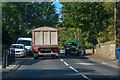
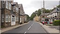
Longframlington : A697
Heading north on the A697.
Image: © Lewis Clarke
Taken: 21 Sep 2020
0.04 miles
2
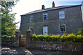
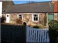
Longframlington : Lishman House
A Grade II listed building https://historicengland.org.uk/listing/the-list/list-entry/1371153
Image: © Lewis Clarke
Taken: 21 Sep 2020
0.04 miles
4

Rimside Gardens
From the junction with Knogley Way
Image: © David Clark
Taken: 9 Feb 2010
0.06 miles
5
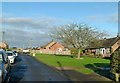
Knogley Way, Longframlington
A small development of sheltered housing.
Image: © Alan Murray-Rust
Taken: 28 Dec 2016
0.06 miles
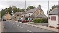
6
Front Street, Longframlington
The A697.
Image: © Richard Webb
Taken: 15 Sep 2018
0.06 miles
7
Front Street, Longframlington
The A697 trunk road passing through the village.
Image: © Alan Murray-Rust
Taken: 28 Dec 2016
0.06 miles
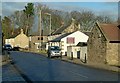
8
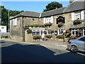
The Granby Inn
Front Street (A697), Longframlington.
Image: © Richard Webb
Taken: 15 Sep 2018
0.06 miles
9
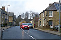
Front Street, Longframlington
The A697 towards Wooler and Coldstream.
Image: © Robin Webster
Taken: 23 Dec 2019
0.06 miles
10
St Mary's Church Rooms
Stand on the north side of the original part of Church Street, opposite the Church.
Image: © David Clark
Taken: 17 Feb 2010
0.07 miles