IMAGES TAKEN NEAR TO
Longframlington, MORPETH, NE65 8AU
Introduction
This page details the photographs taken nearby to NE65 8AU by members of the Geograph project.
The Geograph project started in 2005 with the aim of publishing, organising and preserving representative images for every square kilometre of Great Britain, Ireland and the Isle of Man.

There are currently over 7.5m images from over14,400 individuals and you can help contribute to the project by visiting https://www.geograph.org.uk
Image Map (Loading...)


Getting Data...Please wait
Leaflet Map data © OpenStreetMap
Images are licensed for reuse under creativecommons.org/licenses/by-sa/2.0
Notes
- Clicking on the map will re-center to the selected point.
- The higher the marker number, the further away the image location is from the centre of the postcode.
Image Listing (5 Images Found)
Images are licensed for reuse under creativecommons.org/licenses/by-sa/2.0
Image
Details
Distance
1

The B6344 at Todstead
Looking east along the B6344 close to the junction at Todstead. The road is one of the main routes between Rothbury and the east of the county.
Image: © Graham Robson
Taken: 21 Jul 2018
0.05 miles
2
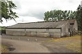
Sheds at Todstead farm
A pair of old farm sheds on the roadside at Todstead.
Image: © Graham Robson
Taken: 21 Jul 2018
0.05 miles

4
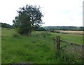
Pasture at Todstead
The River Coquet flows beside the trees on the right.
Image: © Russel Wills
Taken: 17 Jul 2014
0.14 miles
5

The road from Todstead to Longframlington
Above the River Coquet.
Image: © Russel Wills
Taken: 17 Jul 2014
0.14 miles