IMAGES TAKEN NEAR TO
Hillside, MORPETH, NE65 7YW
Introduction
This page details the photographs taken nearby to Hillside, NE65 7YW by members of the Geograph project.
The Geograph project started in 2005 with the aim of publishing, organising and preserving representative images for every square kilometre of Great Britain, Ireland and the Isle of Man.

There are currently over 7.5m images from over14,400 individuals and you can help contribute to the project by visiting https://www.geograph.org.uk
Image Map
Images are licensed for reuse under creativecommons.org/licenses/by-sa/2.0
Notes
- Clicking on the map will re-center to the selected point.
- The higher the marker number, the further away the image location is from the centre of the postcode.
Image Listing (27 Images Found)
Images are licensed for reuse under creativecommons.org/licenses/by-sa/2.0
Image
Details
Distance
2
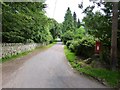
Hillside Road West
Between the wars any ridge or hillside with a view was fair game for high end housing development. There needs to be constant vigilance to stop this happening again, the pressures are there. Still looks a great place to live though.
Image: © Richard Webb
Taken: 1 Jun 2013
0.05 miles
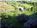
3
Cove Quarry, Pondicherry
Taken as we enter Cove Quarry, just above Pondicherry, Rothbury, at its northern end. Coquetdale, Northumberland.
Image: © Carroll Pierce
Taken: 11 May 2015
0.14 miles
4
Quarry Cove, Pondicherry
Taken as we enter Cove Quarry, just above Pondicherry, Rothbury, at its northern end. Coquetdale, Northumberland.
Image: © Carroll Pierce
Taken: 11 May 2015
0.14 miles
5
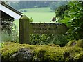
Letterbox
On Hillside Road West, Rothbury.
Image: © Russel Wills
Taken: 31 Jul 2014
0.15 miles
6
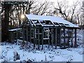
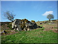
Ruined chalet, Old Rothbury
A correspondent (Michael Hodgson) kindly told me that what I had assumed to be a ruined chalet or holiday home was in fact the pavilion of a former private tennis court. The tennis courts were just in front of the building. There is also said to be a circular stone of a queen's head with the face removed.
http://rothbury.co.uk/around/aroundfrms.htm
Image: © Andrew Curtis
Taken: 6 Feb 2009
0.16 miles
7
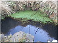
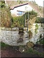
Healthy looking well/spring
Didn't taste it though!
Image: © Leanmeanmo
Taken: 29 Jan 2017
0.16 miles
8
Robin (Erithacus rubecula)
Contemplating a walk to Thropton.
Image: © Russel Wills
Taken: 31 Jul 2014
0.18 miles
9
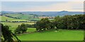
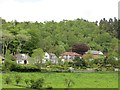
West Hills
Taken from Gimmerknowe, east of Rothbury near Morpeth, Northumberland, I am looking across West Hills and Coquetdale.
Image: © Carroll Pierce
Taken: 10 Sep 2023
0.19 miles
10
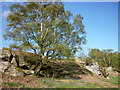
Iron Age fort
Those 'waves' in the grass are what remains of the ramparts of one of the many Iron Age forts constructed in the Rothbury area of Northumberland. I am standing near the top of Ship Crag to get this view.
Image: © Carroll Pierce
Taken: 9 Aug 2014
0.19 miles