IMAGES TAKEN NEAR TO
Back Crofts, MORPETH, NE65 7XY
Introduction
This page details the photographs taken nearby to Back Crofts, NE65 7XY by members of the Geograph project.
The Geograph project started in 2005 with the aim of publishing, organising and preserving representative images for every square kilometre of Great Britain, Ireland and the Isle of Man.

There are currently over 7.5m images from over14,400 individuals and you can help contribute to the project by visiting https://www.geograph.org.uk
Image Map
Images are licensed for reuse under creativecommons.org/licenses/by-sa/2.0
Notes
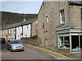
- Clicking on the map will re-center to the selected point.
- The higher the marker number, the further away the image location is from the centre of the postcode.
Image Listing (251 Images Found)
Images are licensed for reuse under creativecommons.org/licenses/by-sa/2.0
Image
Details
Distance
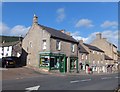
2
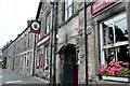
The Turk's Head
In Town Foot. A former coaching inn in the town centre, still offering bed and breakfast.
Image: © Graham Horn
Taken: 1 Sep 2009
0.04 miles
6
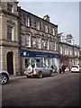
A High Street pharmacy
Boots in Rothbury.
Image: © Stanley Howe
Taken: 10 Apr 2013
0.06 miles
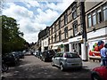
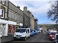
7
Town Foot, Rothbury
At the junction with Providence Lane.
Image: © Barbara Carr
Taken: 15 Sep 2013
0.06 miles
9

A prospect of Rothbury
Seen from Dove Crag, the town of Rothbury in Coquetdale. Beyond the town, the plantations of the Cragside Estate.
Image: © Oliver Dixon
Taken: 14 Jan 2022
0.06 miles
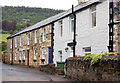
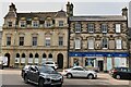
10
NEW
High Street, Rothbury.
The closed shop may be a relocated Co-op.
Image: © Richard Webb
Taken: 25 Feb 2025
0.06 miles