IMAGES TAKEN NEAR TO
Rothbury, MORPETH, NE65 7SQ
Introduction
This page details the photographs taken nearby to NE65 7SQ by members of the Geograph project.
The Geograph project started in 2005 with the aim of publishing, organising and preserving representative images for every square kilometre of Great Britain, Ireland and the Isle of Man.

There are currently over 7.5m images from over14,400 individuals and you can help contribute to the project by visiting https://www.geograph.org.uk
Image Map (Loading...)


Getting Data...Please wait
Leaflet Map data © OpenStreetMap
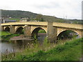
Images are licensed for reuse under creativecommons.org/licenses/by-sa/2.0
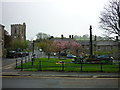
Notes
- Clicking on the map will re-center to the selected point.
- The higher the marker number, the further away the image location is from the centre of the postcode.
Image Listing (267 Images Found)
Images are licensed for reuse under creativecommons.org/licenses/by-sa/2.0
Image
Details
Distance
1
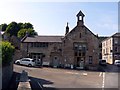
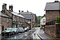
Tomlinsons cafe and bunkhouse Rothbury
Image: © Norman Caesar
Taken: 8 Jul 2013
0.02 miles
2
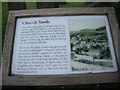
All Saints Churchyards, Rothbury
An information panel about the churchyards and some notable graves.
Image: © Stanley Howe
Taken: 21 Aug 2013
0.02 miles
3
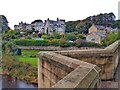
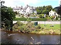
Haw Hill, Rothbury from River Coquet Bridge
Image: © Andrew Curtis
Taken: 17 Oct 2021
0.02 miles
4
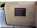
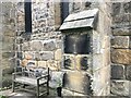
Plaque on Rothbury Bridge
This plaque commemorates the reopening of Rothbury Bridge by the Duchess of Northumberland 14th. December 2012
Image: © Norman Caesar
Taken: 8 Jul 2013
0.02 miles
6
The river bank, Rothbury
Looking across the River Coquet to the north bank from Whitton Bank Road just upstream from Rothbury Bridge, The solar panel powers the adjoining street light. The green structure is a shelter.
Image: © Oliver Dixon
Taken: 31 Jul 2009
0.03 miles
8
Surfeit of sundials
These two 'scratch' or 'mass' sundials (the second one is just about visible 2½ stones to the left) are on the south wall of All Saints Church. These are in addition to the 'main' one, Image
Image: © Leanmeanmo
Taken: 13 Nov 2021
0.03 miles
9
Rothbury Bridge
Grade II listed, Rothbury Bridge probably dates from the late 15th century. The four arched bridge has been widened twice in 1864 and 1927 to accommodate modern traffic. It carries the B6342 across the River Coquet from the south into the main part of Rothbury. Next to the River Tweed, the River Coquet is the premier salmon river in Northumberland.
Image: © G Laird
Taken: 30 Apr 2017
0.03 miles
10
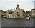
Front Street to Haw Hill, Rothbury
Taken on Front Street / High Street, Rothbury, Northumberland, to Haw Hill. All Saints Parish Church is to the left of shot.
Image: © Carroll Pierce
Taken: 12 May 2015
0.03 miles