IMAGES TAKEN NEAR TO
Deuchet Court, MORPETH, NE65 7SA
Introduction
This page details the photographs taken nearby to Deuchet Court, NE65 7SA by members of the Geograph project.
The Geograph project started in 2005 with the aim of publishing, organising and preserving representative images for every square kilometre of Great Britain, Ireland and the Isle of Man.

There are currently over 7.5m images from over14,400 individuals and you can help contribute to the project by visiting https://www.geograph.org.uk
Image Map (Loading...)


Getting Data...Please wait
Leaflet Map data © OpenStreetMap
Images are licensed for reuse under creativecommons.org/licenses/by-sa/2.0
Notes
- Clicking on the map will re-center to the selected point.
- The higher the marker number, the further away the image location is from the centre of the postcode.
Image Listing (266 Images Found)
Images are licensed for reuse under creativecommons.org/licenses/by-sa/2.0
Image
Details
Distance
1
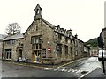
Tomlinson's Cafe and Bunkhouse
There is a date stone above the door to the left - AD 1841. Built for the Free Grammar School, also known as the Tomlinson School after its founder, a local vicar. For more information see Images of England http://www.imagesofengland.org.uk/details/default.aspx?id=236632 . The cafe and bunkhouse opened in 2010.
The building is at the corner of Haw Hill and Bridge Street (right). There is a temporary one-way system in operation here, to manage traffic over a single-lane bailey bridge while the main Rothbury Bridge is being strengthened http://www.geograph.org.uk/photo/2515925 .
Image: © Rose and Trev Clough
Taken: 23 Jun 2011
0.02 miles
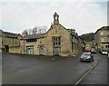
3
Tomlinsons cafe and bunkhouse Rothbury
Image: © Norman Caesar
Taken: 8 Jul 2013
0.02 miles
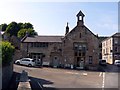
4
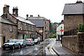
Bridge Street, Rothbury
"A quiet street today; who would have thought that Bridge Street was once such a commercial area!
Grocer and Drapers, Booksellers and Stationers, Game and Poultry Dealers, and Ironmongers, all plied their trade. There was even a Temperance Hotel, and at the southern most end of the bridge a Monumental Masons."
The building on the left was formerly the Boys' School built in 1841. The belfry and large windows were a particular feature of schools in this area. Its last use was that of a motor parts shop and it is currently Tomlinson's Cafe and Bunk house Image
http://rothbury.co.uk/_viltrail/bridge.htm https://web.archive.org/web/20211025085917/http://rothbury.co.uk/_viltrail/bridge.htm
Image: © Andrew Curtis
Taken: 17 Oct 2021
0.02 miles
6
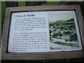
All Saints Churchyards, Rothbury
An information panel about the churchyards and some notable graves.
Image: © Stanley Howe
Taken: 21 Aug 2013
0.02 miles
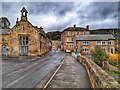
7
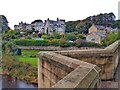
Haw Hill, Rothbury from River Coquet Bridge
Image: © Andrew Curtis
Taken: 17 Oct 2021
0.02 miles
8
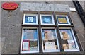
Rothbury Post Office
Old painted sign above the window just legible.
Image: © Barbara Carr
Taken: 15 Sep 2013
0.03 miles
10
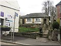
Public toilets, Rothbury
The town centre public toilets in Rothbury, set back from the street and accessed via steps or a very long ramp.
Image: © Graham Robson
Taken: 9 Apr 2016
0.03 miles