IMAGES TAKEN NEAR TO
Tollgate Road, MORPETH, NE65 7RD
Introduction
This page details the photographs taken nearby to Tollgate Road, NE65 7RD by members of the Geograph project.
The Geograph project started in 2005 with the aim of publishing, organising and preserving representative images for every square kilometre of Great Britain, Ireland and the Isle of Man.

There are currently over 7.5m images from over14,400 individuals and you can help contribute to the project by visiting https://www.geograph.org.uk
Image Map (Loading...)


Getting Data...Please wait
Leaflet Map data © OpenStreetMap
Images are licensed for reuse under creativecommons.org/licenses/by-sa/2.0
Notes
- Clicking on the map will re-center to the selected point.
- The higher the marker number, the further away the image location is from the centre of the postcode.
Image Listing (39 Images Found)
Images are licensed for reuse under creativecommons.org/licenses/by-sa/2.0
Image
Details
Distance
1
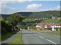
Garleigh Road, Rothbury
A long steep hill into Rothbury from the south. Not to be confused with the road past Cragside which is a longer steeper hill from the north.
Image: © Richard Webb
Taken: 10 Sep 2015
0.07 miles
2
What do you do with an old fire station?
Well, what would you do with it? On a par with Compo's question "How do you get marmalade off a ferret?" On Station Road, Rothbury.
Image: © Oliver Dixon
Taken: 31 Jul 2009
0.10 miles
3
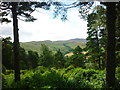
From Cragside to Simonside
Taken on the path which passes just above Cragside house, Northumberland, I am looking across towards Simonside Hills.
Image: © Carroll Pierce
Taken: 11 Aug 2014
0.11 miles
4
Cutting on Disused Railway line
Deep cutting on disused line as the track leaves the former terminus station at Rothbury and runs east along the right bank of the Coquet. The railway line used to run from Rothbury to Scots Gap but passenger services ceased in September 1952
Image: © C Massey
Taken: 16 Feb 2006
0.11 miles
5
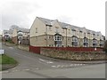
Martfield, Rothbury
A modern housing development of 3 storey houses in Rothbury.
Image: © Graham Robson
Taken: 9 Apr 2016
0.11 miles
6
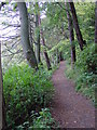
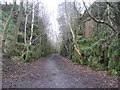
The riverside/woodland path from Rothbury to Thrum Mill.
Image: © Ann Hodgson
Taken: 10 Oct 2004
0.13 miles
7

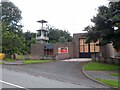
Rothbury fire station
Rothbury fire station, Coquet View, Rothbury, Morpeth, Northumberland, which replaced Image in 2009
Image: © Kevin Hale
Taken: 2 Aug 2010
0.13 miles
8
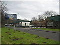
Rothbury railway station (site), Northumberland
Opened in 1870 by the North British Railway as the terminus of the branch line from Morpeth, this station closed to passengers in 1952 and completely in 1963.
View east from roughly where the buffers were, towards brinkburn and Morpeth. The site has been completely redeveloped as an industrial estate and no traces remain.
Image: © Nigel Thompson
Taken: 19 May 2010
0.13 miles
9
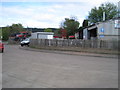
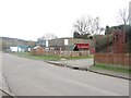
Industrial Estate on old Railway site
Industrial estate set up on site of old railway station and railway line in Rothbury.
Image: © C Massey
Taken: 16 Feb 2006
0.13 miles
10
Rothbury Fire Station
The small fire station from which Rothbury and the surrounding area is covered.
Image: © Graham Robson
Taken: 9 Apr 2016
0.13 miles