
IMAGES TAKEN NEAR TO
Alnwick Road, MORPETH, NE65 7PR
Introduction
This page details the photographs taken nearby to Alnwick Road, NE65 7PR by members of the Geograph project.
The Geograph project started in 2005 with the aim of publishing, organising and preserving representative images for every square kilometre of Great Britain, Ireland and the Isle of Man.

There are currently over 7.5m images from over14,400 individuals and you can help contribute to the project by visiting https://www.geograph.org.uk
Image Map
Images are licensed for reuse under creativecommons.org/licenses/by-sa/2.0
Notes
- Clicking on the map will re-center to the selected point.
- The higher the marker number, the further away the image location is from the centre of the postcode.
Image Listing (79 Images Found)
Images are licensed for reuse under creativecommons.org/licenses/by-sa/2.0
Image
Details
Distance
1
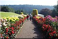
Dahlia Border in summer splendour.
Within the gardens at Cragside.
Image: © Jonathan Billinger
Taken: 10 Sep 2004
0.10 miles

4
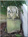
Old Milestone by the B6341, Croft Cottage. Knocklaw
Alnwick number stone by the B6341, in parish of Rothbury (Alnwick District), Knocklaw, formerly opposite Croft Cottage, now broken and removed to cottage garden. Possibly re-erected in its original position - see listing.
Inscription reads:-
: A / 11 : R / 1 :
(To Alnwick and Rothbury)
Northumberland HER.
Reference number: N25694 https://www.heritagegateway.org.uk/Gateway/Results_Single.aspx?uid=N25694&resourceID=110
Milestone Society National ID: NB_RBAN01
Image: © Milestone Society
Taken: Unknown
0.10 miles
5
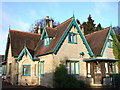
Garden Cottage, Cragside
Built in 1863 for Lord Armstrong's agent on the edge of the estate, beside the formal garden, it is now a National Trust holiday let.
Image: © Derek Harper
Taken: 1 Jan 2007
0.10 miles
6
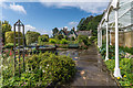
Formal Garden, Cragside
The Formal Garden on the Cragside Estate, with the arbour on the right and Cragside Park House in the background
The whole estate, now owned by the National Trust, is grade I listed - see www.historicengland.org.uk/listing/the-list/list-entry/1001046. Both the arbour and the house are grade II listed - see www.historicengland.org.uk/listing/the-list/list-entry/1354738 and www.historicengland.org.uk/listing/the-list/list-entry/1042076 respectively.
Image: © Ian Capper
Taken: 18 Aug 2019
0.11 miles
7
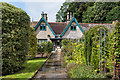
Cragside Park House
House built in 1864 overlooking the formal garden on the Cragside Estate.
The whole estate, now owned by the National Trust, is grade I listed - see www.historicengland.org.uk/listing/the-list/list-entry/1001046. Cragside Park House is grade II listed - see www.historicengland.org.uk/listing/the-list/list-entry/1042076.
Image: © Ian Capper
Taken: 18 Aug 2019
0.11 miles
8
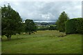
Formal gardens and farmland
Looking across part of the gardens at Cragside and into farmland beyond.
Image: © DS Pugh
Taken: 1 Jul 2022
0.11 miles
9
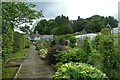
Path towards the Cottage in the Park
Looking across the formal gardens to a cottage available for holiday lets at Cragside.
Image: © DS Pugh
Taken: 1 Jul 2022
0.11 miles
10
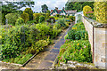
Formal Garden, Cragside
The Formal Garden on the Cragside Estate, with the arbour and Cragside Park House in the background
The whole estate, now owned by the National Trust, is grade I listed - see www.historicengland.org.uk/listing/the-list/list-entry/1001046. Both the arbour and the house are grade II listed - see www.historicengland.org.uk/listing/the-list/list-entry/1354738 and www.historicengland.org.uk/listing/the-list/list-entry/1042076 respectively.
Image: © Ian Capper
Taken: 18 Aug 2019
0.12 miles