IMAGES TAKEN NEAR TO
Rothbury, MORPETH, NE65 7PL
Introduction
This page details the photographs taken nearby to NE65 7PL by members of the Geograph project.
The Geograph project started in 2005 with the aim of publishing, organising and preserving representative images for every square kilometre of Great Britain, Ireland and the Isle of Man.

There are currently over 7.5m images from over14,400 individuals and you can help contribute to the project by visiting https://www.geograph.org.uk
Image Map (Loading...)


Getting Data...Please wait
Leaflet Map data © OpenStreetMap
Images are licensed for reuse under creativecommons.org/licenses/by-sa/2.0
Notes
- Clicking on the map will re-center to the selected point.
- The higher the marker number, the further away the image location is from the centre of the postcode.
Image Listing (28 Images Found)
Images are licensed for reuse under creativecommons.org/licenses/by-sa/2.0
Image
Details
Distance
1

Excellent dry stone wall beside old railway track bed
The moss has selectively grown on the protruding ends of the two rows of through stones, that hold the wall together, and on the top.
Image: © Russel Wills
Taken: 31 Aug 2019
0.10 miles
2
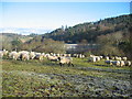
Mill field, Wagtail Farm, Coquet Valley
Sheep grazing in Mill field on banks of Coquet. Opposite is Cragside
Image: © C Massey
Taken: 18 Feb 2006
0.13 miles
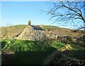
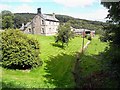
4
Wagtail Farm
Wagtail Farm beside the River Coquet with Cragside in the background.
Image: © J C Ousby
Taken: 12 Dec 2005
0.16 miles
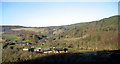
5
Wagtail Farm, Rothbury
Adjoining the old railway to the east of Rothbury.
Image: © Oliver Dixon
Taken: 31 Jul 2009
0.16 miles
6

Track bed crosses Whitton Burn
On the old Northumberland Central Railway.
Image: © Russel Wills
Taken: 31 Aug 2019
0.16 miles
8
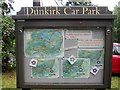
Information board at Dunkirk Car Park. Cragside
On the estate carriage drive. A circular six mile, one way only, around the estate with eight car parks at various points of interest. Restrictions on vehicle height and width
Image: © Martin Dawes
Taken: 31 May 2019
0.18 miles
9

Underpass below old railway track bed
It is high and wide enough for a person to walk through
but could also be for drainage purposes.
Image: © Russel Wills
Taken: 31 Aug 2019
0.19 miles
10
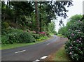
Cragside Carriage Drive leaving Dunkirk c/p
The barrier sticking out into the drive from the right keeps vehicles single file there is an exit past it out onto the B6344
Image: © Martin Dawes
Taken: 31 May 2019
0.19 miles