IMAGES TAKEN NEAR TO
Harbottle, MORPETH, NE65 7DA
Introduction
This page details the photographs taken nearby to NE65 7DA by members of the Geograph project.
The Geograph project started in 2005 with the aim of publishing, organising and preserving representative images for every square kilometre of Great Britain, Ireland and the Isle of Man.

There are currently over 7.5m images from over14,400 individuals and you can help contribute to the project by visiting https://www.geograph.org.uk
Image Map (Loading...)


Getting Data...Please wait
Leaflet Map data © OpenStreetMap
Images are licensed for reuse under creativecommons.org/licenses/by-sa/2.0
Notes
- Clicking on the map will re-center to the selected point.
- The higher the marker number, the further away the image location is from the centre of the postcode.
Image Listing (2 Images Found)
Images are licensed for reuse under creativecommons.org/licenses/by-sa/2.0
Image
Details
Distance

2
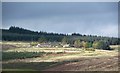
Kidlandlee
A view across the hillsides to this remote settlement in the forest. The area in front of the cottages has been recently cleared of conifers, presumably giving the place more light as well as a view down valley. A local person suggested that at one time there were several families of shepherds up here and that there was even a school, although old 6 inch maps don't reveal anything. Access now is along the valley bottom road which is largely a surfaced track suitable for 4X4 vehicles.
Image: © Gordon Hatton
Taken: 19 Oct 2018
0.04 miles