IMAGES TAKEN NEAR TO
Harbottle, MORPETH, NE65 7BP
Introduction
This page details the photographs taken nearby to NE65 7BP by members of the Geograph project.
The Geograph project started in 2005 with the aim of publishing, organising and preserving representative images for every square kilometre of Great Britain, Ireland and the Isle of Man.

There are currently over 7.5m images from over14,400 individuals and you can help contribute to the project by visiting https://www.geograph.org.uk
Image Map (Loading...)


Getting Data...Please wait
Leaflet Map data © OpenStreetMap
Images are licensed for reuse under creativecommons.org/licenses/by-sa/2.0
Notes
- Clicking on the map will re-center to the selected point.
- The higher the marker number, the further away the image location is from the centre of the postcode.
Image Listing (44 Images Found)
Images are licensed for reuse under creativecommons.org/licenses/by-sa/2.0
Image
Details
Distance
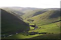
1
Barrowburn from the north
Taken from the bridleway climbing the steep flanks of Barrow Law.
Image: © Andrew Curtis
Taken: 16 Mar 2012
0.01 miles
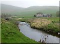
2
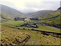
Barrowburn, Upper Coquetdale
The farm in the middle distance is Barrowburn with the neighbouring farm of Windyhaugh just visible behind. The hill on the right of the photograph is Barrow Law whilst the one on the left is Tindale Law. For a selection of detailed free to download walking routes in the area visit www.cheviotwalks.co.uk
Image: © Geoff Holland
Taken: 20 Aug 2020
0.01 miles
3
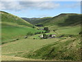
Barrowburn, Upper Coquetdale
The remote farm of Barrowburn enjoys one of the most idyllic locations in Northumberland, nestling beneath the slopes of Shillhope Law and Barrow Law and close to the River Coquet. For a selection of detailed free to download walking routes in the area visit www.cheviotwalks.co.uk
Image: © Geoff Holland
Taken: 19 Apr 2022
0.01 miles
4
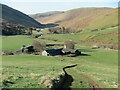
Barrowburn
Barrowburn in Upper Coquetdale.
Image: © Peter McDermott
Taken: 5 May 2008
0.02 miles
6
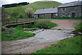
Barrowburn Ford
This ford is found on the River Coquet at Barrowburn.
Image: © John Walton
Taken: 9 May 2014
0.03 miles
7
Barrowburn and Windyhaugh on the Upper Coquet
Image: © John Watson
Taken: 28 May 2006
0.03 miles
8
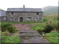
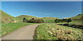
The former Barrowburn farmhouse
This is the former Barrowburn farmhouse with the old valley road passing in front of it. The new farmhouse, a two-storey detached building, stands slightly to the south and out of the photograph. For a selection of free to download walking routes in the area visit www.cheviotwalks.co.uk
Image: © Geoff Holland
Taken: 24 Sep 2013
0.04 miles
9
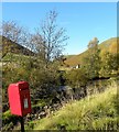
Post box at Barrowburn
Is this the last post box heading up the valley? I don't recall seeing another beyond this point, but if there is, another geograph contributor will have spotted it.
Image: © Gordon Hatton
Taken: 15 Oct 2018
0.04 miles
10
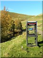
Communications in Upper Coquetdale
I doubt if there's much of a mobile signal in this remote spot, so the good old fashioned TCB probably still has a role to play.
Image: © Gordon Hatton
Taken: 15 Oct 2018
0.04 miles