IMAGES TAKEN NEAR TO
Low Buston, Warkworth, MORPETH, NE65 0XY
Introduction
This page details the photographs taken nearby to NE65 0XY by members of the Geograph project.
The Geograph project started in 2005 with the aim of publishing, organising and preserving representative images for every square kilometre of Great Britain, Ireland and the Isle of Man.

There are currently over 7.5m images from over14,400 individuals and you can help contribute to the project by visiting https://www.geograph.org.uk
Image Map
Images are licensed for reuse under creativecommons.org/licenses/by-sa/2.0
Notes
- Clicking on the map will re-center to the selected point.
- The higher the marker number, the further away the image location is from the centre of the postcode.
Image Listing (18 Images Found)
Images are licensed for reuse under creativecommons.org/licenses/by-sa/2.0
Image
Details
Distance
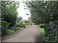
2
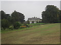
Low Buston Hall
The hall dates to the later 17th century. It underwent a major reconstruction in the late 18th century and further work was carried out in 1907. This is a Grade II Listed Building protected by law.
http://www.keystothepast.info/Pages/pgDetail.aspx?PRN=N14376
Image: © Les Hull
Taken: 17 Sep 2014
0.03 miles
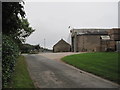
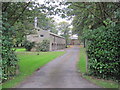
4
Low Buston Farm
The farm buildings and cottages, seen across a field from close to the bridge over Tylaw Burn.
Image: © Derek Harper
Taken: 30 Dec 2006
0.04 miles

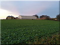
7
Low Buston Farm
Looking across an arable field towards the steading of Low Buston Farm.
Image: © Graham Robson
Taken: 8 Dec 2018
0.14 miles
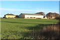
8
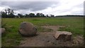
Field, Low Buston
This is strictly arable country and the remains of stock proofing are long gone. The fields are blocked off from the depredations of the tippers and lower quality customers of McDonald's by dolerite boulders.
Image: © Richard Webb
Taken: 15 Sep 2018
0.15 miles