IMAGES TAKEN NEAR TO
Birling, MORPETH, NE65 0XS
Introduction
This page details the photographs taken nearby to NE65 0XS by members of the Geograph project.
The Geograph project started in 2005 with the aim of publishing, organising and preserving representative images for every square kilometre of Great Britain, Ireland and the Isle of Man.

There are currently over 7.5m images from over14,400 individuals and you can help contribute to the project by visiting https://www.geograph.org.uk
Image Map
Images are licensed for reuse under creativecommons.org/licenses/by-sa/2.0
Notes
- Clicking on the map will re-center to the selected point.
- The higher the marker number, the further away the image location is from the centre of the postcode.
Image Listing (128 Images Found)
Images are licensed for reuse under creativecommons.org/licenses/by-sa/2.0
Image
Details
Distance
1
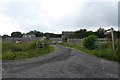
South East Farmsteads
Looking into the entrance of a farm at Birling.
Image: © DS Pugh
Taken: 29 Jul 2016
0.04 miles
2
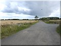
Cycle route at Birling
Just north of Warkworth, the excellent tarmac cycle path which carries National Cycle Network route 1 parallel to the A1068 diverges from the road along this rough stony track.
Image: © Oliver Dixon
Taken: 8 Aug 2018
0.07 miles
5
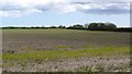
Arable land, Birling
A field passed by many on the way to the beach.
Image: © Richard Webb
Taken: 16 May 2012
0.15 miles
6

Rape field near Warkworth
Caravans at Birling can just be seen over the rape.
Image: © wfmillar
Taken: 24 Apr 2008
0.15 miles
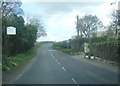
7
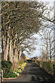
Path leading to Warkworth Cemetery
Image: © Great Northern Cycleway
Taken: 28 Mar 2009
0.17 miles
8

Gateway to bridge across River Coquet at Warkworth, Northumberland
As recently as the 1950s all coastal traffic heading north out of Warkworth had to pass through this arch and across the bridge.
As a child I loved watching trucks squeeze through - there were many scrapes in the rock! The old bridge is no wider. Traffic lights caused lengthy delays at this bottleneck.
Today it's a pathway and I bet few realise how it was not so long ago.
Image: © Chris Morgan
Taken: 6 Oct 2008
0.18 miles
10

Warkworth Cemetery
Part of the older section at the western end.
Image: © Bill Boaden
Taken: 18 May 2013
0.19 miles